Moderators: Elvis, DrVolin, Jeff
![]() by 2012 Countdown » Tue May 03, 2011 7:33 pm
by 2012 Countdown » Tue May 03, 2011 7:33 pm

![]() by Nordic » Tue May 03, 2011 8:29 pm
by Nordic » Tue May 03, 2011 8:29 pm
![]() by eyeno » Tue May 03, 2011 10:44 pm
by eyeno » Tue May 03, 2011 10:44 pm

![]() by eyeno » Tue May 03, 2011 10:52 pm
by eyeno » Tue May 03, 2011 10:52 pm
Representative from the Federal Emergency Management Agency (FEMA) visited the MAE Center on October 26 to discuss ways in which the Center could support the agency’s National Level Exercise 2011 (NLE 2011). NLE is a cycle of seminars, planning events, and exercises designed to strengthen the nation’s capacity to prevent, prepare for, respond to, and recover from All-hazards incidents, including terrorist attacks involving Weapons of Mass Destruction (WMDs). The NLE 2011 will be the agency’s first exercise focused on a natural hazard, a catastrophic New Madrid earthquake event occurring in the middle of the country. FEMA intends to utilize the earthquake scenario that was analyzed as part of their New Madrid Catastrophic Planning Initiative (NMCPI). The MAE Center was the primary earthquake impact modeler for the planning initiative. Discussions at the October meeting were focused on how the MAE Center, and its partner Virginia Tech’s Center for Technology, Security, and Policy, could provide detailed earthquake impact results from the NMCPI project to support the NLE 2011.
Attending the meeting from FEMA were John Aucott, Exercise Program Manager, National Preparedness Director, Gus Wulfkuhle, FEMA Region 5 Operational Planner, and Fred Kaehler, FEMA Region 5. Attendees from the MAE Center included Amr Elnashai, former Director and current consultant, Timothy Gress, Managing Director, and Anisa Como, Researcher.
![]() by 2012 Countdown » Tue May 03, 2011 11:02 pm
by 2012 Countdown » Tue May 03, 2011 11:02 pm
![]() by eyeno » Wed May 04, 2011 12:33 am
by eyeno » Wed May 04, 2011 12:33 am
Report: Radioactive release from nuke plant less than 150 miles from New Orleans
May 3rd, 2011 at 02:49 PM
Nuclear Event – North-America, RSOE Emergency and Disaster Information Service, May 3, 2011:
Summary:
Event type: Nuclear Event
Date / time [UTC]: 03/05/2011 [May 3] – 02:56:08
Area: Grand Gulf Nuclear Power Plant
County / State: State of Mississippi
City: Port Gibson
Event Description:
The Nuclear Regulatory Commission is investigating after a radioactive element is found in the Mississippi river. Authorities say it started at the Grand Gulf Nuclear Plant in Port Gibson. They say they went to check for standing water in an abandoned unit, and found a build up of water. They decided to pump it out, and after taking a sample, they discovered the chemical “tritium” had been released into the river. Officials say the River has diluted the radioactive material, and is not causing harm to the people. Right now the incident is under investigation. There’s no word on how much Tritum was pumped into the water.
![]() by eyeno » Wed May 04, 2011 3:25 am
by eyeno » Wed May 04, 2011 3:25 am
http://www.wwwpropheticseercom.blogspot.com/
Mississippi River overflow about to destruct all the levees on Atchafalaya River barrier
All towns west of Atchafalaya River as far as 29 miles* have the risk of flooding.
Morgan City & Simmesport: Flood Risk - 99%
Lafayette: Flood Risk - 92%
Breaux Bridge, Carencro, Opelousas, Port Barre, Broussard, St. Martinville,
New Iberia, Jeanerette, Franklin, Patterson, Morrow, Cottonport: Flood Risk - 83%
*Yes, 29 miles! The amount of water displacement is enormous:
Almost 1.91 greater than Australian floods and 0.92 greater than the Japan Tsunami!
Also at risk of flooding some towns near the mouth of Red River by backwards flow:
Alexandria: Risk 92% (Backwards flow)
Effie: Risk 83% (Backwards flow)
Marksville & Lecompte: Risk 74% (Backwards flow)
Of course, no need to mention that all the towns near Mississippi River are also at high risk
of severe flooding and sudden underground water collapse (sink-holes) specially:
New Madrid at Missouri
Memphis at Tennessee
Baton Rouge & New Orleans at Louisiana
Links:
http://upload.wikimedia.org/wikipedi...shed_map_1.jpg
http://en.wikipedia.org/wiki/File:Atchafalaya_River.png
http://en.wikipedia.org/wiki/File:Redrivermap1.jpg
http://upload.wikimedia.org/wikipedi...-louisiana.png
http://www.ssd.noaa.gov/goes/east/eaus/flash-rb.html
http://www.wunderground.com/severe.asp?MR=1
The Flood Last Time: Almost Apocalypse
The Mississippi flood of 1973, which is about to be eclipsed in size and duration, came within a hair’s width of changing the history of America by changing the course of the lower Mississippi River. To understand the threat posed by the gathering flood of 2011, we need to know what happened, and what almost happened, nearly 40 years ago at the Old River Control Structure.
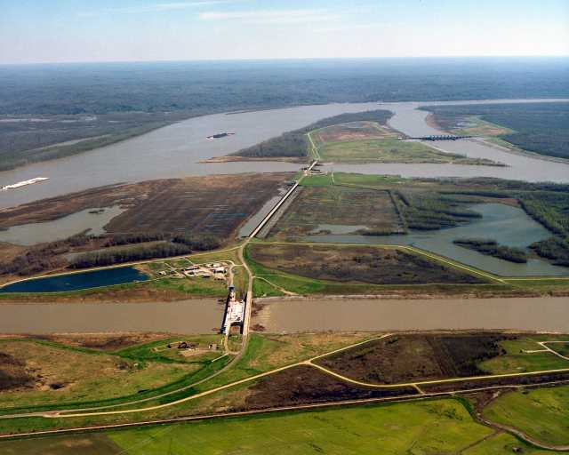
As The Daily Impact has been reporting, almost exclusively (see “Mississippi Rising: Apocalypse Now?” and “Mississippi Rising: Update”), the rising waters of the Mississippi pose an existential threat to the Port of New Orleans and, thus, a large chunk of the economy of the United States. To restate, briefly: the river has been trying for a century to change its lower course, as it had previously done periodically, and was shifting its flow toward the Atchafalaya River, which would take it into the Gulf of Mexico at Morgan City, 65 miles west of New Orleans. In the 1950s, seeing the economic disaster that would be precipitated by this change, the Congress ordered the US Army Corps of Engineers to prevent it.
The Corps built the Old River Control Structure — a huge set of flood gates — on a channel connecting the two rivers to enforce the Congressional mandate that no more than 30% of the Mississippi’s flow would be permitted to enter the Atchafalaya. The war against nature — that is what the Corps called it — was in the “mission accomplished” category for ten years after its construction, that is, until 1973. (More detailed history here.)
That year, the Mississippi recorded a flood stage of 58.2 feet (at Red River Landing just downstream from the Old River Structure). The water cut through the flanks of the structure and undercut its foundation pilings, taking it to the very brink of catastrophic failure. The Corps later reinforced and added to the Structure (that is why it is now, officially, called Old River Control Structures, plural) and assures us that the Mississippi will not change course as long as they are on duty.
As a result of that close call, the late Rafael G. Kazman, along with David B. Johnson, of Louisiana State University studied what would happen if the river does change course. Among their findings (excerpted on the website of America’s Wetland Foundation):
Morgan City would have to be relocated, as would other communities and many businesses, possibly including the massive infrastructure of the offshore oil and gas industry. Fisheries would be altered measurably all across the delta. Oyster reefs would be immediately destroyed, and would take several years to reestablish and become productive (no erysters!). It would probably take two decades to adapt to the new environment around present day Morgan City. Additionally, pipelines, bridges, and the like that cross the Atchafalaya would be destroyed or rendered unsafe.
New Orleans, possibly Baton Rouge, and all other cities and towns along the lower Mississippi would no longer be able to get their drinking water from the river. It would become too salty, since the lower fresh water flow would not offset the tidal movement of the Gulf. Can you imagine the cost of piping or trucking enough drinking (and flushing, etc.) water from north of Lake Pontchartrain to supply the needs of Greater New Orleans? Can you imagine Greater New Orleans without water for drinking and sanitation? Even when the water was just barely increasing in salinity, there would be severe damage to water heaters, fire sprinklers, fire truck pumping systems, and more.
One can also imagine the impact on the nation. Massive use of Federal dollars to protect and restore Louisiana’s infrastructure. Loss of natural gas (there would be brown-outs throughout the eastern seaboard). Commerce would be interrupted by restriction of travel and Louisiana=s inability to focus on supplying items traditionally demanded from her natural resources by the nation. Prices of all Louisiana products (from the natural resources [fisheries, oil, gas] to industrial products [poly vinyl chloride, polyethelene, etc.]) would soar. The interruption of the pogie fisheries would be very negative for such food industries as chicken, catfish, and hogs (see the last section of the notes). New Orleans is one of the most important ports in the nation, and it would suddenly cease to function; all shipping and related industries on the Mississippi River would stop. International trade would be further imbalanced. The massive fertilizer business would shut down and the agriculture industry would falter.
In sum, Katzman and Johnson concluded in 1980, “in the long run the Atchafalaya will become the principal distributary of the Mississippi River and that the current main stem will become an estuary of the Gulf of Mexico…the final outcome is simply a matter of time.”
The question of whether that time is now will be answered in the next 10 days or so.
Tags: 2011 flood, Mississippi River flood, Old River Control Structures
This entry was posted on May 3, 2011 at 8:56 am and is filed under Apocalypse When?. You can follow any responses to this entry through the RSS 2.0 feed.
One Response to The Flood Last Time: Almost Apocalypse
Spartan79 on May 3, 2011 at 5:07 pm
You neglect to mention one other potentially huge impact of the Mississippi’s escape down the Atchafalaya: sections of the I-10 causeway would likely be destroyed, forcing a lot of commercial truck traffic into a 600-mile detour up I-55 to I-20.
This could be a major disaster for the country as a whole. The massive amount of water ponderously making it’s way down the Mississippi is approaching what the Corps describes as a “project flood”: The maximum flood the Old River Control Structures were designed to deal with. And current projections do not include any additional heavy rains in the lower Mississippi basin during the next ten days or so as this situation develops.
And keep your eye on the Gulf and the Caribbean. It’s not too early, and the rains usually associated with any significant tropical depression or storm coming ashore anywhere from Beaumont to Biloxi in the next ten to fifteen days would almost guarantee a catastrophe of biblical proportions.
![]() by eyeno » Wed May 04, 2011 3:48 am
by eyeno » Wed May 04, 2011 3:48 am
The Corps of Engineers blew up a levee in Missouri last night in attempt to save the small town of Cairo, Illinois from flooding.
Wilson says such desperate measures are not expected in Louisiana.
"I do feel comfortable down here the express purpose of the Morganza and Bonnet Carre Spillways were to prevent us from having to do thing like that," said Wilson. "We have floodways that allow us to take the pressure off the river and not have to disassemble levees."
HOUMA — The flood threat facing residents of western Terrebonne has grown more serious as rains continue to feed the swollen Mississippi River.
Flood threats not seen since the Great Mississippi Flood of 1927 has U.S. Army Corps of Engineers officials considering opening the Morganza Spillway north of Baton Rouge, which could send more water tumbling into the Atchafalaya Basin and threatening communities in Terrebonne and St. Mary parishes.
http://www.houmatoday.com/article/20110 ... ay-opening
![]() by eyeno » Wed May 04, 2011 5:17 am
by eyeno » Wed May 04, 2011 5:17 am
"Epic Flooding" of Mississippi River
MEMPHIS, Tenn. - All eyes are on the Mississippi River and its tributaries. Flooding is expected and BBQ fest in Tom Lee Park is in jeopardy.
The river level is just over 36 feet which is well over flood stage. The river rose 2 feet in the last 24 hours, that’s 6 inches more than was forecasted.
The river is forecasted to crest at 45 feet on May 10th, just days before the barbecue cooking competition opens to the public.
The flooding is putting the event in limbo and Memphis and May officials are keeping a close eye on the water level. Music fest this weekend will go on as planned.
Also in danger are homes and businesses near the Loosahatchie River, Wolf River, and Nonconnah Creek. Flooding there will happen over the next few days.
“Right now the Mississippi River is going through what we call an epic flood, meaning it's more than historic, it's more than 100 year flood, it's more like a 500 year flood," said Gene Rench, NWS Surface hydrologist.
Tennessee's two U.S. senators and a West Tennessee congressman have asked the Mississippi River Commission to protect communities in Tennessee from rising Mississippi River floodwaters.
Sens. Lamar Alexander and Bob Corker and Rep. Stephen L. Fincher sent a letter Wednesday to Maj. Gen. Michael J. Walsh, president of the commission.
Officials are deciding whether to punch a massive hole in a levee in southeast Missouri to protect an upstream Illinois town from floodwater.
The three Tennesseans said they were concerned about the potential devastation that could affect about 160,000 Tennesseans.
http://www.myfoxmemphis.com/dpp/news/lo ... t-20110427
![]() by eyeno » Wed May 04, 2011 5:41 am
by eyeno » Wed May 04, 2011 5:41 am
A levee in Poplar Bluff, Missouri, failed on Tuesday, city and county officials said, sending water flooding into a rural but populated area of Butler County, causing the evacuation of more than 6,000 people. People in the area were asked to leave "as soon as possible," Butler County Sheriff's Detective Scott Phelps said.
A levee protecting Bell City, Missouri, also failed, said Dale Moreland, public information officer for the Stoddard County Emergency Management Agency. Bell City schools let out early Tuesday because buses will likely not be able to navigate flooded roads later in the day, Moreland said. Up to 1,200 people south and east of Bell City faced possible evacuation later Tuesday.
The breach was 95 feet wide and 6 to 8 feet deep. About 25 to 30 residences in in the county were affected by the water and a dozen people have been rescued since Monday, according to Moreland.
A levee also failed in nearby Scott County, Moreland said.
![]() by eyeno » Wed May 04, 2011 5:54 am
by eyeno » Wed May 04, 2011 5:54 am
"The Mississippi River tributary system has never been under this type of pressure before," Walsh said. "There's different places of it that's beginning to degrade. We're putting people in those positions and flood-fighting them until they become stabilized."

![]() by eyeno » Wed May 04, 2011 7:08 am
by eyeno » Wed May 04, 2011 7:08 am
DoD/National Defense
NORTHCOM Striking Military Emergency Response Deal with Governors
By: Mickey McCarter
04/06/11
The Department of Defense (DoD) is negotiating with state governors to set rules for more extensive use of the US military during a national disaster, including the activation of Army Reserves, the commander of US Northern Command (NORTHCOM) revealed Tuesday.
DoD has the authority to activate the Reserves on an involuntary basis, said US Navy Adm. James “Sandy” Winnefeld, the NORTHCOM commander during a hearing of the Senate Armed Services Committee, but state governors have resisted the notion in the past as they like to maintain control of armed forces operating within their states during a disaster.
“[T]here has been some historical friction between the state governments and the federal government regarding command and control of military forces inside a state in the wake of a disaster,” Winnefeld testified. “Understandably, the state governors would like to have control, because they are sovereign states, and also understandably, the federal government believes it has a vested interest in -- in federal forces being used legally, ethically, safely and cost-effectively.”
![]() by 2012 Countdown » Wed May 04, 2011 9:14 am
by 2012 Countdown » Wed May 04, 2011 9:14 am
![]() by seemslikeadream » Wed May 04, 2011 9:37 am
by seemslikeadream » Wed May 04, 2011 9:37 am
http://urbansurvival.com/week.htm
And speaking of quakes and such, there's a paper from one Prof. Fran De Aquino which is worth a read if you're into conspiracy theories about the Higth Altitude Auroral Research Program (HAARP). The gist of the paper "High-power ELF radiation generated by modulated HF heating of the ionosphere can cause Earthquakes, Cyclones and localized heating" is a in interesting read for sure, but pay particular attention as to how a slight gravity alteration (top right of page 6) could [theory here] lessen the impact of gravity which in turn, when shut off, might trigger a massive quake.
De Aquino's paper on "The Gravitational Spacecraft" is interesting, and if you get around to duplicating the gravity effects outlined in his paper "Gravity Control by means of Electromagnetic Field through Gas or Plasma at Ultra-Low Pressure" please send along your results. We'd like to convert our old farm truck to mag-lev or better.
Even more curious - to those who follow the 'clues in plain sight' concept -
is this page.

![]() by Canadian_watcher » Wed May 04, 2011 10:03 am
by Canadian_watcher » Wed May 04, 2011 10:03 am

Users browsing this forum: No registered users and 17 guests
Powered by phpBB® Forum Software © phpBB Group
Site design by Likely Arts based on "Deluxe" by Artodia.
