

Moderators: Elvis, DrVolin, Jeff
![]() by brainpanhandler » Tue Dec 30, 2008 7:46 am
by brainpanhandler » Tue Dec 30, 2008 7:46 am

![]() by Joe Hillshoist » Tue Dec 30, 2008 8:43 am
by Joe Hillshoist » Tue Dec 30, 2008 8:43 am
brainpanhandler wrote:
I thought about you Joe when I saw this tropical cyclone blew through northern Australia.
Interesting you mention the lightning is different. It reminded me that the thunder in the last few summers seems markedly different to me. I grew up in the southern US and so I am familiar with thunderstorms, but I don't ever remember hearing thunder so loud in my entire life. It may well be a function of where I live now. I've only lived at my current address for 3 years. Maybe the sound propagates differently. I don't know. But the thunder around here occasionally sounds more like massive bombs going off across town. I mean there's none of the usual rumbling and build up to the crash. There's just an enormous explosion.
![]() by brainpanhandler » Wed Dec 31, 2008 12:31 pm
by brainpanhandler » Wed Dec 31, 2008 12:31 pm

![]() by brainpanhandler » Thu Jan 01, 2009 8:40 am
by brainpanhandler » Thu Jan 01, 2009 8:40 am
![]() by Joe Hillshoist » Thu Jan 01, 2009 8:43 pm
by Joe Hillshoist » Thu Jan 01, 2009 8:43 pm
![]() by brainpanhandler » Sat Jan 03, 2009 12:50 am
by brainpanhandler » Sat Jan 03, 2009 12:50 am
![]() by brainpanhandler » Tue Feb 01, 2011 9:21 pm
by brainpanhandler » Tue Feb 01, 2011 9:21 pm
NASA satellites capture data on monster winter storm affecting 30 states (w/ Video)
February 1, 2011
It has already been called one of the largest winter storms since the 1950s and it is affecting 30 U.S. states today with snow, sleet, freezing rain and rain. NASA satellites have gathering data on the storm that stretches from Texas and the Rockies to the New England states.
....
![]() by brainpanhandler » Tue Feb 01, 2011 9:41 pm
by brainpanhandler » Tue Feb 01, 2011 9:41 pm
Intense Blizzard Rolls Across the U.S.
A massive winter storm system is rolling across the Plains and Midwest U.S., headed for the New England Region. Snow amounts of up to three feet have been dumped in some parts of Illinois and Indiana, and more is on its way. Whereas the Midwest is plagued with snow, ice will be the danger in Pennsylvania. Temperatures are warming from Maryland south, which will bring only rain to the Mid-Atlantic and Southeast.
This animation shows the last 24 hours of GOES-East satellite infrared water vapor imagery. The blue colored areas show the most intense, moist areas of the atmosphere that are responsible for these major precipitation events. Also included, at the end, is the snow precipitation amounts from Jan 31 - Feb 1, 2011.
![]() by Cosmic Cowbell » Tue Feb 01, 2011 9:52 pm
by Cosmic Cowbell » Tue Feb 01, 2011 9:52 pm


![]() by Jeff » Tue Feb 01, 2011 10:51 pm
by Jeff » Tue Feb 01, 2011 10:51 pm
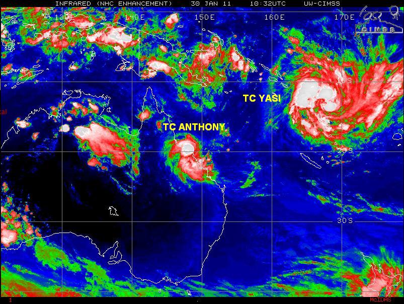
Cosmic Cowbell wrote:Take care down under Ozlings...
Australia's Cyclone Yasi may destroy even 'cyclone proof' homes
Feb 2 (Reuters) - Australia's Cyclone Yasi, with winds of up to 300 km (186 miles) per hour, is so powerful it could blow apart even "cyclone proof" houses, engineers said on Wednesday.
Yasi is headed for major towns and cities along the northeast coast. It is believed to be the strongest ever to hit Australia, surpassing Cyclone Tracy which largely destroyed the northern city of Darwin in 1974.
"Once you get to extreme cases, you are in uncharted ground and the test data I have got I would not trust it if I had to live there myself," said Dr Robert Leicester, a researcher with the government's national scientific research body.
...

![]() by 82_28 » Tue Feb 01, 2011 11:33 pm
by 82_28 » Tue Feb 01, 2011 11:33 pm

![]() by 82_28 » Wed Feb 02, 2011 12:24 am
by 82_28 » Wed Feb 02, 2011 12:24 am
Weather conditions across the Chicago area have gone from bad to worse over the past couple of hours as winds gusting to 60mph whip heavy snow into drifts. Intense thundersnow is now moving into northeast Illinois and weather conditions will continue to go downhill throughout the night. Unfortunately, the situation is going to get a lot worse overnight before things slowly improve Wednesday afternoon.
![]() by mentalgongfu2 » Wed Feb 02, 2011 1:00 am
by mentalgongfu2 » Wed Feb 02, 2011 1:00 am

![]() by smiths » Wed Feb 02, 2011 3:12 am
by smiths » Wed Feb 02, 2011 3:12 am
Mass evacuations are underway in the northeastern Australian state of Queensland in anticipation of what forecasters expect will be the largest cyclone ever to hit the continent.
Yasi threatens to batter the coast with 300km/h winds and a storm surge up to 7m late tonight.
Don't panic if roof lifts off: authorities
Windows will explode, roofs will lift and homes on stumps may simply fall over and crumble when category five Cyclone Yasi crosses the coast, experts say.

![]() by Gnomad » Wed Feb 02, 2011 9:40 am
by Gnomad » Wed Feb 02, 2011 9:40 am
Users browsing this forum: No registered users and 15 guests