Moderators: Elvis, DrVolin, Jeff
![]() by Iamwhomiam » Wed Dec 03, 2014 5:03 pm
by Iamwhomiam » Wed Dec 03, 2014 5:03 pm
![]() by seemslikeadream » Wed Dec 03, 2014 8:48 pm
by seemslikeadream » Wed Dec 03, 2014 8:48 pm

![]() by Searcher08 » Wed Dec 03, 2014 9:47 pm
by Searcher08 » Wed Dec 03, 2014 9:47 pm
Iamwhomiam » Wed Dec 03, 2014 9:03 pm wrote:Lord Balto will be excited to see his theory affirmed. Thank you, Searcher.
 I think we'll need an "I TOLD YOU SO!" emoticon for him!
![]() by Elvis » Thu Dec 04, 2014 6:22 am
by Elvis » Thu Dec 04, 2014 6:22 am
Searcher08 » Wed Dec 03, 2014 1:07 pm wrote:From Graham Hancock's Facebook page
THE FINGERPRINT OF A GLOBAL CATACLYSM 12,800 YEARS AGO
https://en.wikipedia.org/wiki/Charles_Hapgood
Charles Hutchins Hapgood (May 17, 1904 – December 21, 1982)[1] was an American college professor and author who became one of the best known advocates of the claim of a rapid and recent pole shift with catastrophic results.
Hapgood received a master's degree from Harvard University in 1929 in medieval and modern History. His Ph.D. work on the French Revolution was interrupted by the Great Depression. He taught for a year in Vermont and directed a community center in Provincetown, also serving as the executive secretary of Franklin Roosevelt's Crafts Commission.
During World War II, Hapgood was employed by the Center of Information (which later became the Office of Strategic Services and then the Central Intelligence Agency) and the Red Cross, and also served as a liaison officer between the White House and the Office of the Secretary of the War. After the war, Hapgood taught at Keystone College (1945–1947), Springfield College (1947–1952), Keene State College (1956–1966), and New England College (1966–1967), lecturing in world and American history, anthropology, economics, and the history of science.
[...]
Hapgood spent ten years working with New England medium Elwood Babbitt (b. 1922), attempting to make contact with notable figures from the past. Babbitt, a retired carpenter and World War II veteran, had studied trance mediumship at Edgar Cayce's Association for Research and Enlightenment. Hapgood audiotaped and transcribed a number of Babbitt's "trance lectures" which purported to come from Jesus, Albert Einstein, Mark Twain, and the Hindu god Vishnu,[13] using the material to publish his final three books:Voices of Spirit, Through the Psychic Experience of Elwood Babbitt (1975), Talks with Christ and His Teachers Through the Psychic Gift of Elwood Babbitt (1981), and The God Within: a Testament of Vishnu, a Handbook for the Spiritual Renaissance (1982). [1] During this time Babbitt and Hapgood's cousin, Beth Hapgood worked closely with the nearby Brotherhood of the Spirit New Age commune. After Charles Hapgood's death, Beth Hapgood, assembled a final volume of Babbitt's trance lectures, Dare the Vision and Endure (1997).
Charles Hapgood first came to public attention in the mid-1950s with his theory of earth crust displacement, a radical geological idea which attracted the curiosity and support of Albert Einstein. The Einstein-Hapgood correspondence is a forgotten page in the history of science. We obtained these letters (ten from Einstein to Hapgood) from Albert Einstein’s Archives in the Fall of 1995. They show, for the first time, just how extensively Albert Einstein was involved in assisting Charles Hapgood in the development of the theory of earth crust displacement.
In his second reply (24 November 1952) to Hapgood, Einstein wrote that the idea of earth crust displacement should not be ruled out "a priori" just because it didn’t fit with what we wanted to believe about the earth’s past. What was needed, Einstein claimed, was solid "geological and paleontological facts."
For six months, Hapgood gathered geological evidence to support the idea of an earth crust displacement. On the 3rd of May 1953 he forwarded thirty-eight pages of this evidence to Einstein. Central to his argument was Hapgood’s evidence that Lesser Antarctica was ice-free at the same time that North America lay smothered in ice. Einstein responded (8 May 1953):
"I find your arguments very impressive and have the impression that your hypothesis is correct. One can hardly doubt that significant shifts of the crust have taken place repeatedly and within a short time."
He urged Hapgood to follow up on evidence of "earth fractures". A month later (11 June 1953) Hapgood sent Einstein forty-two pages of evidence on earth fractures and the evolution of the ice sheets.
Einstein wrote (17 December 1953) Hapgood urging him to address the "centrifugal momentum" problem. Hapgood responded with four pages on this problem and thirty-seven pages of "paleontological evidence" including the frozen mammoths of Arctic Siberia. Einstein was now convinced. On the 18th of May 1954, Einstein wrote a very favorable foreword for Hapgood’s book EARTH’S SHIFTING CRUST: A KEY TO SOME BASIC PROBLEMS OF EARTH SCIENCE (published in 1958 by Pantheon Books, New York). The Foreword begins:
"I frequently receive communications from people who wish to consult me concerning their unpublished ideas. It goes without saying that these ideas are very seldom possessed of scientific validity. The very first communication, however, that I received from Mr. Hapgood electrified me...."
Hapgood and Einstein continued to correspond and finally met in January of 1955. Einstein’s last letter was dated the 9th of March 1955 just weeks before the great physicist died on the 18th of April 1955. Einstein’s Archives are held in Jerusalem (with copies at Princeton) where they hold the record of an unique and unheralded collaboration on the theory of earth crust displacement.
http://www.bibliotecapleyades.net/atlan ... ida_9a.htm
FOREWORD by Albert Einstein
I frequently receive communications from people who wish to consult me concerning their unpublished ideas. It goes without saying that these ideas are very seldom possessed of scientific validity. The very first communication, however, that I received from Mr. Hapgood electrified me. His idea is original, of great simplicity, and if it continues to prove itself, of great importance to everything that is related to the history of the earth's surface.
A great many empirical data indicate that at each point on the earth's surface that has been carefully studied, many climatic changes have taken place, apparently quite suddenly. This, according to Hapgood, is explicable if the virtually rigid outer crust of the earth undergoes, from time to time, extensive displacement over the viscous, plastic, possibly fluid inner layers. Such displacements may take place as the consequence of comparatively slight forces exerted on the crust, derived from the earth's momentum of rotation, which in turn will tend to alter the axis of rotation of the earth's crust.
In a polar region there is continual deposition of ice, which is not symmetrically distributed about the pole. The earth's rotation acts on these unsymmetrically deposited masses, and produces centrifugal momentum that is transmitted to the rigid crust of the earth. The constantly increasing centrifugal momentum produced in this way will, when it has reached a certain point, produce a movement of the earth's crust over the rest of the earth's body, and this will displace the polar regions toward the equator.
Without a doubt the earth's crust is strong enough not to give way proportionately as the ice is deposited. The only doubtful assumption is that the earth's crust can be moved easily enough over the inner layers.
The author has not confined himself to a simple presentation of this idea. He has also set forth, cautiously and comprehensively, the extraordinarily rich material that supports his displacement theory. I think that this rather astonishing, even fascinating, idea deserves the serious attention of anyone who concerns himself with the theory of the earth's development. To close with an observation that has occurred to me while writing these lines: If the earth's crust is really so easily displaced over its substratum as this theory requires, then the rigid masses near the earth's surface must be distributed in such a way that they give rise to no other considerable centrifugal momentum, which would tend to displace the crust by centrifugal effect. I think that this deduction might be capable of verification, at least approximately. This centrifugal momentum should in any case be smaller than that produced by the masses of deposited ice.

![]() by slimmouse » Thu Dec 04, 2014 8:42 am
by slimmouse » Thu Dec 04, 2014 8:42 am

![]() by seemslikeadream » Sat Jan 10, 2015 11:29 pm
by seemslikeadream » Sat Jan 10, 2015 11:29 pm
![]() by Joe Hillshoist » Sun Jan 11, 2015 2:16 am
by Joe Hillshoist » Sun Jan 11, 2015 2:16 am
![]() by slimmouse » Sun Jan 11, 2015 3:04 am
by slimmouse » Sun Jan 11, 2015 3:04 am
Joe Hillshoist » 11 Jan 2015 06:16 wrote:Slim anything can map anything if you're a good enough artist. Every river, well at least some, in Australia has been used to map the milky way onto earth.
Also ... the human brain is far more complex than Orion. Any map of the human brain that is as simple as Orion isn't much of a map.
![]() by seemslikeadream » Thu Jan 15, 2015 2:53 pm
by seemslikeadream » Thu Jan 15, 2015 2:53 pm

![]() by Joe Hillshoist » Fri Jan 16, 2015 12:58 am
by Joe Hillshoist » Fri Jan 16, 2015 12:58 am
slimmouse » 11 Jan 2015 17:04 wrote:Joe Hillshoist » 11 Jan 2015 06:16 wrote:Slim anything can map anything if you're a good enough artist. Every river, well at least some, in Australia has been used to map the milky way onto earth.
Also ... the human brain is far more complex than Orion. Any map of the human brain that is as simple as Orion isn't much of a map.
I have no doubt that many aussie rivers can Joe, but how many incorporate the Great Pyramids at the precise metaphysical intersection, pointing to the brain in Orion?
https://en.wikipedia.org/wiki/Pyramid_%28brainstem%29
This is more than just "Good art". It s a metaphysical map scientifically compiled, rather than just some strange series of Sychronicities.
The ancient Egyptians were fully aware of all of this.
As an aside Its more a question of exactly how ancient this information is. JMHO, but it clearly seems to be further back than anything that the current historical model woulld indicate - not that the purveyors of our current model would ever accept these hard facts as anything remotely approaching such.
![]() by seemslikeadream » Sat Jan 17, 2015 9:48 pm
by seemslikeadream » Sat Jan 17, 2015 9:48 pm
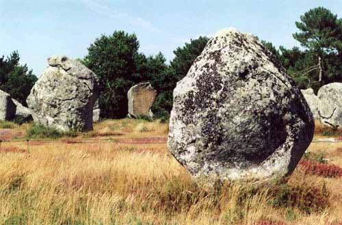
The Myth and Enduring Mystery of the Carnac Stones
January 12, 2015 Micah Hanks
Though its name bears resemblance to Upper Egypt’s ancient ceremonial temple, the commune known as Carnac, located in southern Brittany, France, is associated with the mysteries of the ancients for more than just its name. For here, a neolithic mystery also exists, involving ancient standing stones numbering in excess of 3,000.
These tall, upright-standing stones at Carnac, or menhirs as they are sometimes called throughout parts of western Europe, are the stuff of local legend. One myth associates them with Saint Cornelius, long held to have been the first Gentile to have converted to Christianity. In this particular folktale, Cornelius was being pursued by a Roman legion, and by invoking the power of Christ, he transformed the soldiers into stone, where they remain today; hence, the perfect straightness of their alignment is explained, according to this version of the story. A similar English variation holds that, rather than Cornelius, it had been none other than the famous magician Merlin who cast this stony spell upon the advancing legion.
In truth, the Arthurian variation holds a bit more weight, if only in that the history of the stones and their present formation certainly dates back to pre-Christian times, likely around 3300 BC, though the exact age of the site remains in question.
The greater question, of course, has to do with how the peoples of neolithic western Europe could have moved the stones–some of them massive in proportion–and also moved so many of them into place. Of equal interest in this mystery is what purpose they served, for which there are many theories and curious possibilities.
Dating back to the late 18th century, it had been suggested that the standing stones of Carnac might have been utilized by druids in their rituals. Others have suggested that they may have been erected in alignment with the stars, much akin to more modern alternative theories about ancient temples and structures, most famously the Egyptian pyramids at Giza. By the early 1800s, excavations were undertaken at the site, in which more theories were proposed, again suggesting celestial alignment and other astronomical theories the likes of which have been offered in relation to Stonehenge further to the north.
Two slabs of the four that comprise the famous, and massive, "Broken Menhir" at Locmariaquer.
This theory may be justified somewhat, according to its proponents, due in part to similar reflections made on sites nearby, such as the massive “Broken Menhir” of Er Grah, located at Locmariaquer. This impressive menhir once stood upright, and at 20 meters, it was without question the tallest of its kind anywhere in the world. It’s modern name is derived, of course, from the fact that it now rests upon the ground, broken into four large stone slabs. And yet, much like the standing stones of Carnac, the great Broken Menhir of Locmariaquer is perhaps the most curious of all, since archaeological data proves that it not only once stood upright, but also that those who erected the monolith had likely done so as long ago as 4700 BC. What knowledge could have made this possible among the ancient Europeans, apart from elbow grease and unrivaled determination, is indeed a mystery.
Modern visitors to the region will find not only the remaining menhirs that have lasted the centuries, but also wandering goats who assist in keeping weed growth within manageable jurisdiction. Since the early 1900s, the stones have been protected as state-owned property, to prevent the inevitable borrowing by local quarrymen and builders that might have destroyed them, as fate met by similarly strange monuments found elsewhere in France. With little doubt, people will continue to marvel over their striking appearance against the French landscape; whether they were lifted in tribute to ancient lives by long-deceased family members, or they are ancient astronomical aids as many suggest, their existents serves to inspire our curiosity.
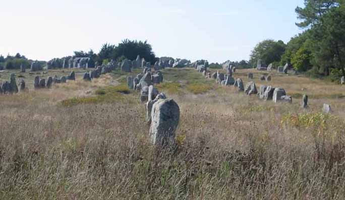
The Carnac Stones
The Carnac stones are an exceptionally dense collection of megalithic sites around the French village of Carnac, in Brittany, consisting of alignments, dolmens, tumuluses and single menhirs. The more than 3,000 prehistoric standing stones were hewn from local rock and erected by the pre-Celtic people of Brittany, and are the largest such collection in the world.
Local tradition claims that the reason they stand in such perfectly straight lines is that they are a Roman legion turned to stone by Merlin - Brittany has its own local versions of the Arthurian cycle. Most of the stones are within the French commune of Carnac, but some to the east are within La TrinitŽ-sur-Mer.The stones were erected at some stage during the Neolithic period, probably around 3300 BC, but some may date to as old as 4500 BC.
In recent centuries, many of the sites have been neglected, with reports of dolmens being used as sheep shelters, chicken sheds or even ovens. Even more commonly, stones have been removed to make way for roads, or as building materials. The continuing management of the sites remains a controversial topic.
There are three major groups of stone rows - Menec, Kermario and Kerlescan - which may have once formed a single group, but have been split up as stones were removed for other purposes.
Menec alignments
Eleven converging rows of menhirs stretching for 1,165 metres, by 100 metres wide. There is what Alexander Thom considered to be the remains of stone circles at either end. According to the tourist office there is a "cromlech containing 71 stone blocks" at the western end and a very ruined cromlech at the eastern end. The largest stones, around four metres high, are at the wider, western end; the stones then become as small as 0.6 metres high along the length of the alignment before growing in height again toward the extreme eastern end.
Kermario ("house of the dead") alignment
This fan-like layout recurs a little further along to the east in the Kermario alignment. It consists of 1029 stones in ten columns, about 1,300 metres in length. A stone circle to the east end, where the stones are shorter, was revealed by aerial photography.
Kerlescan alignments
A smaller group of 555 stones, further to the east of the other two sites. It is composed of 13 lines with a total length of about 800 metres, ranging in height from 80 cm to 4 metres. At the extreme west, where the stones are tallest, there is a stone circle which has 39 stones. There may also be another stone circle to the north.
Petit-Menec alignments
A much smaller group, further east again of Kerlescan, falling within the commune of La TrinitŽ-sur-Mer. These are now set in woods, and most are covered with moss and ivy.
There are several tumuluses, mounds of earth built up over a grave. In this area, they generally feature a passage leading to a central chamber which once held neolithic artefacts.
Saint-Michel
The tumulus of Saint-Michel was constructed between 5000 BC and 3400 BC. At its base it is 125 m by 60 m, and is 12 m high. It required 35,000 mã of stone and earth. Its function was the same as that of the pyramids of Egypt: a tomb for the members of the ruling class. It contained various funerary objects, such as 15 stone chests, pottery, jewellery, most of which are currently held by the Museum of Prehistory of Carnac. It was excavated in 1862 by Rene Galles with a series of vertical pits, digging down 8 metres. Le Rouzic also excavated it between 1900 and 1907 discovering the tomb and the stone chests.A chapel was built on top in 1663 but was rebuilt in 1813, before being destroyed in 1923. The current building is an identical reconstruction of the 1663 chapel, built in 1926.
The Manio Giant
Near the quadrilateral is a single massive menhir, now known as the "Giant". Over 6.5 metres tall, it was re-erected around 1900 by Zacharie Le Rouzic, and overlooks the nearby Kerlescan alignment.
The mŽnec alignments of some 1100 stones in 11 columns.
The famous Dolmen of Crucno, in the middle of a small Breton village.
The chamber consists of nine pillars supporting a capstone weighing over 40 tonnes.
![]() by seemslikeadream » Sat Jan 24, 2015 3:15 am
by seemslikeadream » Sat Jan 24, 2015 3:15 am
Eggshell World Globe Might be the First to Depict The Americas
January 23, 2015 Martin J. Clemens
So there’s been something of a theme to my work of late; my research notes would have you believe that I’ve become a cartophile – that is, a lover of maps (not to be confused with a lover of baseball cards). I admit, I do love maps. Especially antique maps, ancient maps. But it’s more of a passing fancy than an obsession, though I’m about to make that a little less believable.
I’ve brought you the story of ancient celestial spheres, also known as Islamacate Spheres. I’ve discussed the peculiarities of famous maps out of antiquity, such as the Piri Reis and the Dulcert 1339 maps. I’ve even examined the case for early Greek celestial knowledge through rudimentary star maps on pottery. I’ve shared with you all the various forms of maps, from portolan charts, to globes, to celestial spheres and everything in between.
Today though… today I bring you ostrich eggs. Or more accurately, antique maps etched onto the preserved shells of ostrich eggs. One particular example may in fact be the oldest surviving globe to show the New World.
ostrich-globe
Map makers, or cartographers, have been making maps for millennia, and while most surviving examples are either drawn on vellum or delicate parchment, the more creative among the tradition have used all kinds of materials in their art, from petrified wood, to bone, to ivory. You name it, someone at some point has used it to make a map.
Globes have typically been made of some kind of metal, such as bronze, or copper, or even precious metals. Often they’re cast models on which their maker carves his marks and titles and locations. It’s painstaking work, and the results are often incredibly beautiful. In the case of ostrich egg globes, the delicate nature of the eggshell and the size of the detail make them not only extremely rare, but equally impressive. Artists today have produced stunning works of art on the surface of eggs, but the delicate nature of the medium makes it even more extraordinary that any eggshell globes have survived at all.
The pictured example was found at a London map fair in 2012, and eventually found its way into the hands of a Belgian map collector named Stefaan Missinne. Aside from being a most beautiful and rare antique oddity, it wasn’t thought to be particularly important, until Missinne started his year-long study.
Having been a hidden gem in an anonymous collector’s holdings, Missinne was shocked to find that this globe could in fact be the oldest surviving world globe to depict the Americas. According to a paper submitted to the journal The Portolan (of the Washington Map Society) by Missinne, the ostrich egg globe is a near perfect duplicate of the now famous Hunt-Lenox Globe, a copper terrestrial globe that has held that title since about 1870.[1]
With a not dissimilar story of discovery, the Hunt-Lenox Globe has been dated to c. 1510 AD, and is now a center piece of the New York Public Library’s Rare Books Division collection. Both globes show the Americas (both north and south) as small islands in the far west Atlantic Ocean, but even with this glaring inaccuracy, it’s held that they are the first representations of the New World on a globe of any kind. Thought there are portolan charts with these details that predate the globes by several decades.
This eggshell globe, though, does have a curious feature not seen on the Hunt-Lenox Globe. According to Missinne, it is the very first map of any kind to show Newfoundland.
Detail of a ship in the eastern Indian Ocean on the egg globe. Image credit: Washington Map Society
The ostrich egg globe, which as yet does not have a name, has been dated to 1502-1508, and this leads some to believe that the egg was used as the design model for the Hunt-Lenox Globe. Interestingly, the ostrich egg globe was dated by comparing the density of calcium contained in the eggshell to that of newer eggs of known age. Unfortunately, the eggshell globe is likely to remain officially uncrowned as the first to show the New World, since its provenance is entirely unknown prior to 2012. Missinne and his colleagues have been able to date the eggshell, and their analysis is reliable, but the eggshell could be much older than the carvings, which means anyone could have created the globe at some point since 1510 up until it was found in London.
If you are at all familiar with cartographic history, dating these globes to the early 16th century should be no surprise. It seems that there was something of a boon in the trade of map making during that period, and several examples of maps dating to between 1450-1580 show remarkable progress in the knowledge and skill of these craftsmen, as well as general knowledge of the world at large. This was, in fact, the height of the Renaissance period, where the genius of men like Leonardo da Vinci was being recognised and shared among scholars, and the dark ages finally gave way to the modern era. Missinne, strangely enough, actually attempts to attribute this eggshell globe to The Master himself, though few scholars agree that da Vinci had anything to do with it.
These surviving examples of the genius and skill of our forbearers are a testament to what humanity can achieve. There was a new world out there, and the adventure of exploring and discovering the unknown was a powerful force. But one didn’t need to be Christopher Columbus to satisfy that urge, cartographers, surveyors, and artisans all played their part. Without the makers of these wondrous oddities, we might not have gotten to where we are quite so fast.
That same spirit of exploration can still be felt, though it isn’t as conspicuous as it once was. Those on the front lines of scientific discovery, no matter the field, are the true adventurers of our time.
![]() by seemslikeadream » Tue Feb 10, 2015 8:31 am
by seemslikeadream » Tue Feb 10, 2015 8:31 am
100 Ancient Cult Sites Discovered in Israel
by Owen Jarus, Live Science Contributor | February 09, 2015 07:45am ET
One of the 100 cult sites, dating back around 8,000 years, discovered in Israel's Eilat Mountains reveals a penis-shaped structure pointing toward the remains of a stone circle.
Credit: Courtesy Uzi Avner
Some 100 prehistoric "cult sites," complete with penis stone structures and artifacts with vulva shapes cut into them, have been discovered in the Eilat Mountains, an extremely arid area of the Negev Desert in Israel.
At the sites, which date back around 8,000 years, archaeologists discovered a variety of stone structures and artifacts, including stone circles that measure 1.5 to 2.5 meters across (roughly 5 to 8 feet) with penis-shaped installations pointing toward them. Other findings there include standing stones that reach up to 2.6 feet (80 centimeters) high, stone bowls and stone carvings that have a humanlike shape.
These sites are often clustered together. In one area the team discovered 44 cult sites in a spot encompassing only 0.8 square kilometers (less than 200 acres). "Taking in[to] consideration the topography, environmental conditions and the small number of known Neolithic habitations in the general southern Negev, the density of cult sites in this region is phenomenal," the team wrote in an article published recently in the Journal of the Israel Prehistoric Society. [See Photos of the Cult Sites and Stone Structures]
These sites were used for ritual activities of some form. Archaeologists know little about what activities went on at these sites although animal sacrifice, as seen from bones found there, seems to be one of them.
Fertility and death
Archaeologists are working to decipher any meaning from the artifacts and structures, noting that both death and fertility seem to be symbolized at the sites.
For instance, in addition to the penis-shaped structures, researchers also found that some of the stones have vulva-shaped holes cut into them. The circles that the penis-shaped structures point to also seem to represent females.
"The circle is a female symbol, and the elongated cell is a male one (phallus)," said Uzi Avner, a researcher with the Arava-Dead Sea Science Center and the Arava Institute, in an email to Live Science.
Humanlike stone carvings were also found at the 100 cult sites.
Credit: Courtesy Uzi AvnerView full size image
Death is "signified by the burial of stone objects and by setting them upside down," the team members wrote in their paper. In one case, a humanlike stone carving was found buried "with only the very top visible on the surface."
The two symbols identified so far, fertility and death, go hand in hand in many cultures. "Combinations of both are actually well-known in anthropological studies as relating to ancestral cult," the archaeologists wrote.
Harsh landscape
The 100 cult sites were found in a mountainous area that receives only 20 mm (0.79 inches) of rain per year, on average, the archaeologists said.
Around 8,000 years ago it would have been somewhat wetter. "The climate of the 7th-6th millennia B.C. was a little moister than that of the present, 40%-20% more rainfall, but the desert was a desert," said Avner in the email.
The cult sites tended to be built in relatively flat sections of the mountains. "Their position on topographic 'shoulders' or comparatively flat locations probably enabled several dozens of people to gather around them, for example, an extended family," the archaeologists wrote.
The sites also provide a good view. "Commonly, a broad view is seen from the sites, so possibly, the scenery was one element in the selection of their location," the archaeologists added.
While the researchers discovered many cult sites, they found few domestic ones. "In contrast to the density of cult sites, only two small habitations and one small campsite were found on the ridge," they wrote, noting that these three sites were all associated with the cult sites.
More cult sites to discover
Many more sites in the area remain to be surveyed and described in published papers, Avner told Live Science. A "survey of a larger area yielded to date 349 cult sites," he said, adding that researchers are preparing these finds for publication.
"The number of cult sites recorded to date suggests that many more still await discovery," the researchers wrote."Many more may be found on the mountains of the Negev, southern Jordan and Sinai."
One "may think now of a vast phenomenon, of hundreds of mountain cult sites in the desert."
![]() by jakell » Tue Feb 10, 2015 9:12 am
by jakell » Tue Feb 10, 2015 9:12 am

![]() by coffin_dodger » Tue Feb 10, 2015 11:00 am
by coffin_dodger » Tue Feb 10, 2015 11:00 am

Users browsing this forum: No registered users and 9 guests