Maybe this topic could be retitled to reflect its eclectic scope?
Moderators: Elvis, DrVolin, Jeff
![]() by Perelandra » Mon Apr 07, 2014 4:14 pm
by Perelandra » Mon Apr 07, 2014 4:14 pm

![]() by seemslikeadream » Tue May 13, 2014 9:49 am
by seemslikeadream » Tue May 13, 2014 9:49 am
Stonehenge Discovery 'Blows Lid Off' Old Theories About Builders Of Ancient Monument (VIDEO)
The Huffington Post | by Macrina Cooper-White
From who built it to what it was used for, Stonehenge is surrounded by many enduring mysteries -- and researchers from the University of Buckingham in England now say they've solved one of them.
"For years people have been asking why is Stonehenge where it is, now at last, we have found the answers,” David Jacques, an archaeology research fellow at the university, said in a written statement.
Last October, Jacques led an archaeological dig at a site 1.5 miles from Stonehenge. His team unearthed flint tools and the bones of aurochs, extinct cow-like animals that were a food source for ancient people. Carbon dating of the bones showed that modern-day Amesbury, an area that includes the dig site and Stonehenge itself, has been continuously occupied since 8820 B.C. Amesbury has now been declared the oldest continually occupied area in Britain.
The finding suggests that Stonehenge was built by indigenous Britons who had lived in the area for thousands of years. Previous theories held that the monument was built in an empty landscape by migrants from continental Europe.
"The site blows the lid off the Neolithic Revolution in a number of ways," Jacques said in the statement, referring to the assumption that those migrants drove Britain's transition from a hunter-gatherer to a farming society in the 6th Century B.C. "It provides evidence for people staying put, clearing land, building, and presumably worshipping, monuments."
The researchers say evidence suggests that before erecting Stonehenge, people living in the area set up gigantic timbers between 8820 and 6590 B.C. -- a sort of wooden precursor to the stone monument. Jacques likened the area to a "Stonehenge Visitor's Center," where visitors from far and wide came to feast and tour the site with local guides.
"The area was clearly a hub point for people to come to from many miles away, and in many ways was a forerunner for what later went on at Stonehenge itself," he said.

![]() by seemslikeadream » Sat Jun 21, 2014 9:40 am
by seemslikeadream » Sat Jun 21, 2014 9:40 am
![]() by seemslikeadream » Tue Jun 24, 2014 9:50 am
by seemslikeadream » Tue Jun 24, 2014 9:50 am


Strange Stone Spheres Top List of New World Heritage Spots
Enigmatic archaeological sites in Costa Rica dotted with mysterious stone spheres are among six newly designated as UNESCO World Heritage Sites.
The stone sphere sites, on the Diquis Delta in southern Costa Rica, join places like the Great Wall of China and Yellowstone National Park on the list of 1,007 sites designated as World Heritage Sites by the United Nations Educational, Scientific and Cultural Organization (UNESCO). The organization lists places that are "of outstanding universal value," based on criteria such as representing a masterpiece of creative genius, recording testimony of a vanished civilization, or containing exceptional natural beauty.
The U.N.'s World Heritage Committee, currently meeting in Doha, Qatar, announced the additions to the list today (June 23). Other than the Diquis Delta sites, the new honorees include the architectural remnants of a medieval Eurasian city, spectacular landscapes in Vietnam and India, a wildlife sanctuary in the Philippines and a site offering geological evidence of the meteorite collision that killed off the dinosaurs. [See Photos of the New World Heritage Sites]
![]() by seemslikeadream » Tue Aug 26, 2014 9:04 am
by seemslikeadream » Tue Aug 26, 2014 9:04 am
What Lies Beneath Stonehenge?
A groundbreaking survey of the site has turned up tantalizing new clues to what really went on there
By Ed Caesar
SMITHSONIAN MAGAZINE | SUBSCRIBE
SEPTEMBER 2014
We walked the Avenue, the ancient route along which the stones were first dragged from the River Avon. For centuries, this was the formal path to the great henge, but now the only hint of its existence was an indentation or two in the tall grass. It was a fine English summer’s day, with thin, fast clouds above, and as we passed through fields dotted with buttercups and daisies, cows and sheep, we could have been hikers anywhere, were it not for the ghostly monument in the near distance.
Stonehenge-A New Understanding: Solving the Mysteries of the Greatest Stone Age Monument
Faint as the Avenue was, Vince Gaffney hustled along as if it were illuminated by runway lights. A short, sprightly archaeologist of 56, from Newcastle upon Tyne in northeast England, he knows this landscape as well as anyone alive: has walked it, breathed it, studied it for uncounted hours. He has not lost his sense of wonder. Stopping to fix the monument in his eyeline, and reaching out toward the stones on the horizon, he said, “Look, it becomes cathedralesque.”
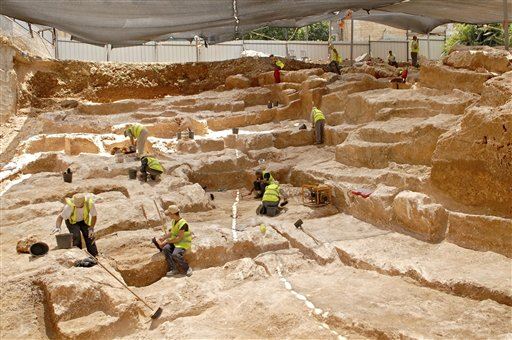
Gaffney’s latest research effort, the Stonehenge Hidden Landscapes Project, is a four-year collaboration between a British team and the Ludwig Boltzmann Institute for Archaeological Prospection and Virtual Archaeology in Austria that has produced the first detailed underground survey of the area surrounding Stonehenge, totaling more than four square miles. The results are astonishing. The researchers have found buried evidence of more than 15 previously unknown or poorly understood late Neolithic monuments: henges, barrows, segmented ditches, pits. To Gaffney, these findings suggest a scale of activity around Stonehenge far beyond what was previously suspected. “There was sort of this idea that Stonehenge sat in the middle and around it was effectively an area where people were probably excluded,” Gaffney told me, “a ring of the dead around a special area—to which few people might ever have been admitted....Perhaps there were priests, big men, whatever they were, inside Stonehenge having processions up the Avenue, doing...something extremely mysterious. Of course that sort of analysis depends on not knowing what’s actually in the area around Stonehenge itself. It was terra incognita, really.”
The huge bluestones each weigh between four and eight tons and were brought to the site from North Wales, 170 miles away. (Photo by Henrik Knudsen, with thanks to English Heritage)
The Stonehenge landscape, the new evidence suggests, guided the movement of great crowds. (Photo by Henrik Knudsen, with thanks to English Heritage)
The heelstone aligns with the rising sun on the summer solstice as seen from the stone circle, about 80 yards away. It is one of “an excessive number” of such features in the Stonehenge landscape. (Photo by Henrik Knudsen, with thanks to English Heritage)
The massive stone monument rising from Salisbury Plain must have been an impressive sight to ancient visitors (above, the site at dawn). (Photo by Henrik Knudsen, with thanks to English Heritage)
The Stonehenge Hidden Landscapes Project used ground-penetrating radars (left) and GPS-guided magnetometers (right) to produce what amounts to a 3-D map of a four-square-mile area. (Photo by Henrik Knudsen, with thanks to National Trust, Stonehenge, Wiltshire)
Nighttime only enhances the mystery of Stonehenge (above, a pair of enormous trilithons). Was it a temple? A graveyard? A healing place? (Photo by Henrik Knudsen, with thanks to English Heritage)
Scholars believe the first stones were erected at Stonehenge around 2600 B.C. and that construction continued on the site for a millennia. (Photo by Henrik Knudsen, with thanks to English Heritage)
AROUND THE WEB
Nobody has yet put a spade in the ground to verify the new findings, which were painstakingly gathered by geophysicists and others wielding magnetometers and ground-penetrating radars that scan the ground to detect structures and objects several yards below the surface. But Gaffney has no doubt of the work’s value. “This is among the most important landscapes, and probably the most studied landscape, in the world,” he says. “And the area has been absolutely transformed by this survey. Won’t be the same again.”
***
The joys and frustrations of all archaeological study—perhaps all historical inquiry—come into particularly sharp relief at Stonehenge. Even to the most casual observer, the monument is deeply significant. Those vast stones, standing in concentric rings in the middle of a basin on Salisbury Plain, carefully placed by who-knows-who thousands of years ago, must mean something. But nobody can tell us what. Not exactly. The clues that remain will always prove insufficient to our curiosity. Each archaeological advance yields more questions, and more theories to be tested. Our ignorance shrinks by fractions. What we know is always dwarfed by what we can never know.
Take the big question: Was Stonehenge predominantly a temple, a parliament or a graveyard? Was it a healing ground? We don’t know, for sure. We know that people were buried there, and that the stones are aligned in astronomically important ways. We also understand, because of the chemical composition of animal bones found nearby and the provenance of the stones, that people traveled hundreds of miles to visit Stonehenge. But we cannot say, with certainty, why.
A full map of the project’s findings is to be presented September 9 at the British Science Festival in Birmingham, England. (David Preiss)
Try a simpler question: How did the bluestones, which weigh between four and eight tons apiece, arrive at the site, nearly 5,000 years ago, from 170 miles away in North Wales? Land or sea? Both alternatives explode with possibilities, and nobody has an impregnable theory. Mike Parker Pearson of University College London is working on a new idea that the bluestones might have been lifted onto huge wooden lattices and carried by dozens of men to the site. But it’s just a theory. We can’t know, definitively. We can only have better-informed questions.
The ineffability of Stonehenge has not dulled our appetite. The site has long proved irresistible to diggers. In 1620, the Duke of Buckingham had his men excavate right in the center of the monument. Although they did not know it at the time, they dug on the site of a prehistoric pit. Buckingham’s men found skulls of cattle “and other beasts” and large quantities of “burnt coals or charcoals”—but no treasure, as they had hoped.
In the 19th century, “barrow-digging,” or the excavation of prehistoric monuments and burial hills, was a popular pastime among the landed gentry. In 1839, a naval officer named Captain Beamish dug out an estimated 400 cubic feet of soil from the northeast of the Altar Stone at Stonehenge. As Parker Pearson notes in his book Stonehenge, Beamish’s “big hole was probably the final blow for any prehistoric features...that once lay at Stonehenge’s center.”
Cursus outlined in special effects. (© October Films for Smithsonian Channel)
Vince Gaffney (in a special effects scene in the film Stonehenge Empire) stands above the mysterious pit at the western end of the Cursus. (© October Films for Smithsonian Channel)
Frames from Stonehenge Empire show stones whose locations were determined only in 2013. (© October Films for Smithsonian Channel )
The monument as it would have appeared in its Neolithic heyday. (© October Films for Smithsonian Channel)
Work at Stonehenge became less invasive. In 1952, Willard Libby—the American chemist and later a Nobel Prize winner—used his new radiocarbon dating technique on a piece of charcoal from a pit within Stonehenge to date the monument to 1848 B.C., give or take 275 years. That date has since been refined several times. The prevailing opinion is that the first stones were erected on the site around 2600 B.C. (although the building of Stonehenge was carried out over a millennium, and there were centuries of ritual activity at the site before the stones were in place).
In 2003, Parker Pearson conducted his own survey, concentrating on the nearby settlement at Durrington Walls and the area between there and the River Avon. Based on huts, tools and animal bones he uncovered, he concluded that Durrington Walls likely housed the workers who built Stonehenge. Based on an analysis of human remains he later excavated from Stonehenge, he also surmised that, far from being a site of quotidian religious activity, Stonehenge served as a cemetery–a “place for the dead.”
The Stonehenge Hidden Landscapes Project is different from everything that came before it. When Gaffney and his team started their work, they were less interested in theories than in data. To that end, they concentrated on taking what amounts to a three-dimensional and yards-deep photograph of the entire landscape. “The perceived wisdom was driven by the monuments we knew about,” says Gaffney. “We’ve put in the data between the monuments.”
***
Chris Gaffney, Vince’s younger, slighter and less voluble brother, was one of the instigators of this new approach. The duo’s grandfather was a metalwork teacher from Newcastle with an interest in archaeology, who took his clever grandchildren on trips to Hadrian’s Wall, the old barrier between the Roman Empire and the blasted north. Small wonder that Vince became an archaeologist and Chris a geophysicist, now at the University of Bradford.
The Gaffney brothers’ interest in new technologies that were becoming available to archaeologists led them to the first GPS-guided magnetometer systems. A magnetometer has sensors that allow a geophysicist to see evidence of historic building, and even ancient ditch-digging, beneath the soil by mapping variations in the earth’s magnetic field. The GPS-guided versions were able to pinpoint some of those discoveries to within one centimeter. The Gaffneys believed that Stonehenge scholarship needed a massive magnetometer- and radar-led survey of the whole site. “We just didn’t know if anything’s there,” Vince Gaffney recalled. “So we’re constructing various hypotheses on the basis of something we don’t know.”
Around the same time, an Austrian archaeologist named Wolfgang Neubauer, now of the Boltzmann Institute, was hoping to conduct large-scale projects all over Europe using tools including GPS magnetometers and ground-penetrating radar. Neubauer’s team had also developed software to process the 40 or 50 gigabytes of raw data that these instruments could create in a day. Suddenly, instead of waiting weeks or months to see what the machines had found, it was possible to cover several acres with magnetometers and radar in a day and to display that information on a screen almost instantaneously.
One of the areas Neubauer wanted to scan was Stonehenge, and in the spring of 2009 he contacted Vince Gaffney. A few months later, the Boltzmann Institute and the University of Birmingham—plus several other British and European universities, museums and companies that contributed expertise and resources—began their collaboration at Stonehenge.
Their first days on site, Gaffney recalled, were “like a geophysical circus has come to town.” Tractors pushed the ground-penetrating radars, which looked like high-powered lawn mowers. All-terrain vehicles dragged the magnetometer sensors on long strings. Delicate instruments covering hard, uneven ground kept mechanics and technicians busy. “I have seen one of our magnetometers shear clear apart in front of me,” said Gaffney. “It was back in service the next day.” In all, the fieldwork took about 120 days, spread over four years.
***
In a multimedia room at the University of Birmingham there was a vast touch screen, six feet by nine, on which a new map of the Stonehenge landscape appeared. Gaffney pointed out the key features.
There was Stonehenge itself, marked by the familiar circles. To the north was the long, thin strip called the Stonehenge Cursus or the Greater Cursus, which was demarcated by ditches, and ran east to west for nearly two miles. (The Cursus was given its name by the antiquarian William Stukeley in the 18th century because it looked like an ancient Roman race course. Its construction predates the first building work at Stonehenge by several hundred years.) Gaffney also pointed out the Cursus Barrows—hillocks containing mass human graves—just south of the Cursus itself, and King Barrow Ridge to the east.
Scattered all over the map were blotches of black: features without names. These were new finds, including the more than 15 possible new or poorly understood Neolithic monuments. Gaffney emphasized possible, acknowledging that it will require digging—“the testimony of the spade”—to discover precisely what was there.
Standing in front of this constellation of evidence, he seemed unable to decide where to start, like a child at the Christmas tree. “These are little henge monuments,” he said, touching the screen to highlight a group of black smudges. “Nice little entrance there, and a ditch. These things we know nothing about.”
He saved his greatest enthusiasm for the discoveries that had been made in the Cursus. This feature, said Gaffney, had always been thought of as a “bloody great barrier to the north of Stonehenge.” Nobody knew quite what it was for. Because the Cursus runs east to west, archaeologists have always believed that its presence owes something to the passage of the sun. The monument must be significant: It was dug in the fourth millennium B.C. using antler picks—hundreds of thousands of man-hours went into its construction.
The Hidden Landscapes Project’s instruments discovered several new clues. First of all, they found gaps in the ditch, in particular a very large break in the northern side, to allow people to enter and exit the Cursus. Now, instead of seeing the Cursus exclusively as a monument that encouraged movement along the path of the sun, east to west, Gaffney began to consider these gaps as “channels through the landscape” to guide the movement of people north to south.
A bigger discovery, Gaffney says, was a “bloody huge” pit about five yards in diameter at the eastern end of the Cursus. Today it lies buried at least three feet below the surface of the ground. Such a pit was much too large for a practical use—for instance, burying trash—because of the labor involved in digging it. In the archaeologists’ minds it could only have ritual implications, as “a marker of some kind,” Gaffney said. What’s more, if you drew a straight line between the pit and the heelstone at Stonehenge, it ran directly along the final section of the Avenue, on the path of the sunrise on the summer solstice.
“We thought, That’s a bit of a coincidence!” Gaffney recalled. “That was the point at which we thought, What’s at the other end? And there’s another pit! Two pits, marking the midsummer sunrise and the midsummer solstice, set within a monument that’s meant to be something to do with the passage of the sun.”
With his hands passing over the map, Gaffney showed how—on the longest days of the year—the pits formed a triangle with Stonehenge marking sunrise and sunset.
“Nobody had ever seen these pits before,” he continued. “But they link the area of Stonehenge with the Cursus directly. Either these things have been put inside the Cursus to mark these points, or the Cursus has been wrapped around them.”
What was so interesting about the Cursus pits was that they told a story about the landscape. The “sunrise” pit was visible from Stonehenge, but the “sunset” pit was not—it was nestled behind a ridge, and could have been seen only if there had been fire and smoke coming from it. (At some point the pits will have to be excavated for evidence of such activity.) These discoveries fed into a larger understanding of Stonehenge as “diachronic”—operating in light and dark, sunrise and sunset, day and night.
“The point I think we’re coming to,” said Gaffney, “is that increasingly we can see the area around Stonehenge as providing extensive evidence for complex liturgical movement—which we can now understand, largely because we know where things are.”
Parker Pearson, for his part, takes a cautious view of the new research. “Until you dig holes, you just don’t know what you’ve got,” he told me in his office at University College London. “What date it is, how significant it is. [There are] extraordinary new features coming up, and we’re thinking well, what are they?”
To be sure, he said the data from the Hidden Landscapes Project “backs up the pattern we’ve already been seeing for some years. We have an excessive number of solstice-aligned monuments in that landscape. Nowhere in the rest of Europe comes even close.” He added, “This is fantastic stuff that’s been done, and it’s raised a whole series of new questions,” he said. “It’s going to take years.”
***
The clouds shifted in front of the sun, dappling the landscape with shadow. Gaffney and I were walking the Avenue, 300 yards or so from Stonehenge, and in the distance a string of barrows gleamed like opals. Although he acknowledged the fallibility of all archaeological projection (“In the end,” he said, “we are all wrong”), his work has led him to a new interpretation of how Stonehenge was used.
Gaffney’s idea was not to focus on Stonehenge itself, but on “processionality” within the whole landscape. He imagined people moving around the area like Roman Catholics processing through the Stations of the Cross. He recalled an Easter Friday ritual he saw in Croatia, in which a “bloke with a cross” led fellow barefoot celebrants on a miles-long trip. In Gaffney’s view, the building of the great stone circle was a “monumentalizing” of a similar, if heathen, procession.
As we walked downhill through the fields, Gaffney stopped from time to time to point out the hillocks in which “the illustrious dead” were buried. He also noted how the Avenue was not a straight line between the Avon and Stonehenge, but rather a series of tacks that brought the visitor to the Stonehenge site in a “theatrical” way, along the line of sunrise on the summer solstice.
He thrust himself into the mind of a Bronze Age visitor to the site. “You will have seen nothing like it,” he said. “It would have been massively impressive.” Soon we descended into a valley called Stonehenge Bottom, only a hundred yards or so from the great stones. “They’re disappearing....Watch, just watch!” he said.
Within a few yards, the monument became invisible. When you picture Stonehenge in your mind’s eye, you imagine the concentric rings of vast stones standing in a desolate open landscape, visible for miles around. But now, here we were, a hundred yards away, and the thing had gone.
We stood in a field, watched by some lethargic cows, and savored the strangeness of the moment. Then, as we stepped uphill, Stonehenge re-emerged on the horizon. It happened fast. The lintels, then the great sarsens, then the smaller bluestones were suddenly before us.
Gaffney’s voice lifted. He spoke about Jerusalem Syndrome: the feeling of intense emotion experienced by pilgrims on their first sighting of the Holy City. In the prehistoric world, there was no conception of God as he was understood by the later Abrahamic faiths. But, said Gaffney, as Stonehenge reappeared before us, “whatever the ancient version of Jerusalem Syndrome is, that’s what you’re feeling now.”
![]() by seemslikeadream » Wed Sep 17, 2014 4:09 pm
by seemslikeadream » Wed Sep 17, 2014 4:09 pm
Massive 5,000-Year-Old Stone Monument Revealed in Israel
By Owen Jarus, Live Science Contributor | September 15, 2014 07:27am ET
About 8 miles (13 kilometers) northwest of the Sea of Galilee, a newly identified crescent-shaped monument was built about 5,000 years ago.
A lunar-crescent-shaped stone monument that dates back around 5,000 years has been identified in Israel.
Located about 8 miles (13 kilometers) northwest of the Sea of Galilee, the structure is massive — its volume is about 14,000 cubic meters (almost 500,000 cubic feet) and it has a length of about 150 meters (492 feet), making it longer than an American football field. Pottery excavated at the structure indicates the monument dates to between 3050 B.C. and 2650 B.C., meaning it is likely older than the pyramids of Egypt. It was also built before much of Stonehenge was constructed.
Archaeologists previously thought the structure was part of a city wall, but recent work carried out by Ido Wachtel, a doctoral student at the Hebrew University of Jerusalem, indicates there is no city beside it and that the structure is a standing monument.
"The proposed interpretation for the site is that it constituted a prominent landmark in its natural landscape, serving to mark possession and to assert authority and rights over natural resourcesby a local rural or pastoral population," Wachtel wrote in the summary of a presentation given recently at the International Congress on the Archaeology of the Ancient Near East. [See Photos of the Crescent-Shaped Monument]
The structure's crescent shape stood out in the landscape, Wachtel told Live Science in an email. The shape may have had symbolic importance, as the lunar crescent is a symbol of an ancient Mesopotamian moon god named Sin, Wachtel said.
An ancient town called Bet Yerah (which translates to "house of the moon god") is located only a day's walk from the crescent-shaped monument Wachtel noted. As such, the monument may have helped mark the town's borders. While the monument is located within walking range of the city it is too far away to be an effective fortification.
Massive structure
The structure is about 150 meters (492 feet) long and 20 m (66 feet) wide at its base, and is preserved to a height of 7 m (23 feet), Wachtel's research found.
"The estimation of working days invested in the construction [of] the site is between 35,000 days in the lower estimate [and] 50,000 in the higher," Wachtel said in the email.
If the lower estimate is correct, it means a team of 200 ancient workers would have needed more than five months to construct the monument, a task that would be difficult for people who depended on crops for their livelihood. "We need to remember that people were [obligated] most of the year to agriculture," Wachtel said.
Bet Yerah
At the time this monument was built, the site of Bet Yerah was located only 18 miles (29 km) away.
Bet Yerah was a large town with a grid plan and fortification system, according to a study detailed in 2012 in the Journal of Near Eastern Archaeology. Its inhabitants traded with the early kings of Egypt, as seen from several artifacts, including a jug with a hieroglyphic inscription.
The name Bet Yerah indicates that it was associated with the moon god. However, it's uncertain whether the town actually bore this name 5,000 years ago. In the 2012 journal article, researchers said the name "Bet Yerah" was recorded in 1,500-year-old Jewish rabbinic texts and may date back much earlier.
Megalithic landscape
Other large rock structures have been found not far from the crescent-shaped monument. One structure, called Rujum el-Hiri, isin the Golan Heights (an area to the east of the Sea of Galilee) and has four circles with a cairn at its center. The date of this structure is a matter of debate; recent research by Mike Freikman, an archaeologist with the Hebrew University of Jerusalem, suggests it may predate the crescent-shaped structure by several centuries.
Another stone monument, a giant cairn that weighs more than 60,000 tons, was discovered recently beneath the waters of the Sea of Galilee. Its date is unknown, but like the crescent-shaped structure, it is located close to Bet Yerah.
Wachtel's work at the crescent-shaped monument was conducted as part of his master's thesis.Today, people living in the area call the monument by its Arabic name, Rujum en-Nabi Shua'ayb, and it is sometimes referred to as the "Jethro Cairn," a reference to the Druze prophet Jethro, who plays an important role in local folklore.
![]() by seemslikeadream » Wed Sep 24, 2014 1:18 pm
by seemslikeadream » Wed Sep 24, 2014 1:18 pm
22 September 2014 Last updated at 20:14 ET
Beyond Angkor: How lasers revealed a lost city
By Ben Lawrie
Documentary film-maker
Angkor Wat temple
Deep in the Cambodian jungle lie the remains of a vast medieval city, which was hidden for centuries. New archaeological techniques are now revealing its secrets - including an elaborate network of temples and boulevards, and sophisticated engineering.
In April 1858 a young French explorer, Henri Mouhot, sailed from London to south-east Asia. For the next three years he travelled widely, discovering exotic jungle insects that still bear his name.
Today he would be all but forgotten were it not for his journal, published in 1863, two years after he died of fever in Laos, aged just 35.
Mouhot's account captured the public imagination, but not because of the beetles and spiders he found.
Readers were gripped by his vivid descriptions of vast temples consumed by the jungle: Mouhot introduced the world to the lost medieval city of Angkor in Cambodia and its romantic, awe-inspiring splendour.
"One of these temples, a rival to that of Solomon, and erected by some ancient Michelangelo, might take an honourable place beside our most beautiful buildings. It is grander than anything left to us by Greece or Rome," he wrote.
His descriptions firmly established in popular culture the beguiling fantasy of swashbuckling explorers finding forgotten temples.
Today Cambodia is famous for these buildings. The largest, Angkor Wat, constructed around 1150, remains the biggest religious complex on Earth, covering an area four times larger than Vatican City.
It attracts two million tourists a year and takes pride of place on Cambodia's flag.
Dr Dan Penny finds medieval carvings under a stone bridge in the Cambodian jungle
Follow the archaeological team in Cambodia as they uncover the mysteries of Angkor Wat. Watch Jungle Atlantis on Thursday 25 September at 20:00 BST on BBC Two or catch it later on the BBC iPlayer.
Jungle Atlantis
But back in the 1860s Angkor Wat was virtually unheard of beyond local monks and villagers. The notion that this great temple was once surrounded by a city of nearly a million people was entirely unknown.
It took over a century of gruelling archaeological fieldwork to fill in the map. The lost city of Angkor slowly began to reappear, street by street. But even then significant blanks remained.
Then, last year, archaeologists announced a series of new discoveries - about Angkor, and an even older city hidden deep in the jungle beyond.
An international team, led by the University of Sydney's Dr Damian Evans, had mapped 370 sq km around Angkor in unprecedented detail - no mean feat given the density of the jungle and the prevalence of landmines from Cambodia's civil war. Yet the entire survey took less than two weeks.
Their secret?
Lidar - a sophisticated remote sensing technology that is revolutionising archaeology, especially in the tropics.
Mounted on a helicopter criss-crossing the countryside, the team's lidar device fired a million laser beams every four seconds through the jungle canopy, recording minute variations in ground surface topography.
The findings were staggering.
Image showing what is beneath the ground at Angkor
Lidar technology has revealed the original city of Angkor - red lines indicate modern features including roads and canals
The archaeologists found undocumented cityscapes etched on to the forest floor, with temples, highways and elaborate waterways spreading across the landscape.
"You have this kind of sudden eureka moment where you bring the data up on screen the first time and there it is - this ancient city very clearly in front of you," says Dr Evans.
These new discoveries have profoundly transformed our understanding of Angkor, the greatest medieval city on Earth.
Phra Sav Ling Povn, palace of the leprous king, near the great temple of Angkor Wat, circa 1930
Phra Sav Ling Povn, palace of the leprous king, near Angkor Wat, circa 1930
At its peak, in the late 12th Century, Angkor was a bustling metropolis covering 1,000 sq km. (It would be another 700 years before London reached a similar size.)
Angkor was once the capital of the mighty Khmer empire which, ruled by warrior kings, dominated the region for centuries - covering all of present-day Cambodia and much of Vietnam, Laos, Thailand and Myanmar. But its origins and birthplace have long been shrouded in mystery.
A few meagre inscriptions suggested the empire was founded in the early 9th Century by a great king, Jayavarman II, and that his original capital, Mahendraparvata, was somewhere in the Kulen hills, a forested plateau north-east of the site on which Angkor would later be built.
But no-one knew for sure - until the lidar team arrived.
The lidar survey of the hills revealed ghostly outlines on the forest floor of unknown temples and an elaborate and utterly unexpected grid of ceremonial boulevards, dykes and man-made ponds - a lost city, found.
Relief map of Mahendraparvata
Most striking of all was evidence of large-scale hydraulic engineering, the defining signature of the Khmer empire.
By the time the royal capital moved south to Angkor around the end of the 9th Century, Khmer engineers were storing and distributing vast quantities of precious seasonal monsoon water using a complex network of huge canals and reservoirs.
Harnessing the monsoon provided food security - and made the ruling elite fantastically rich. For the next three centuries they channelled their wealth into the greatest concentration of temples on Earth.
One temple, Preah Khan, constructed in 1191, contained 60t of gold. Its value today would be about £2bn ($3.3bn).
But despite the city's immense wealth, trouble was brewing.
At the same time that Angkor's temple-building programme peaked, its vital hydraulic network was falling into disrepair - at the worst possible moment.
The end of the medieval period saw dramatic shifts in climate across south-east Asia.
Tree ring samples record sudden fluctuations between extreme dry and wet conditions - and the lidar map reveals catastrophic flood damage to the city's vital water network.
With this lifeline in tatters, Angkor entered a spiral of decline from which it never recovered.
In the 15th Century, the Khmer kings abandoned their city and moved to the coast. They built a new city, Phnom Penh, the present-day capital of Cambodia.
Life in Angkor slowly ebbed away.
Angkor Wat
When Mouhot arrived he found only the great stone temples, many of them in a perilous state of disrepair.
Nearly everything else - from common houses to royal palaces, all of which were constructed of wood - had rotted away.
The vast metropolis that once surrounded the temples had been all but devoured by the jungle.
Watch the first episode of Jungle Atlantis on Thursday 25 September at 20:00 BST on BBC Two, or catch it later on the BBC iPlayer. The programme was made in association with The Smithsonian Channel, which will be transmitting both episodes in the US on 5 October under the title Angkor Revealed.
![]() by cptmarginal » Thu Sep 25, 2014 6:17 pm
by cptmarginal » Thu Sep 25, 2014 6:17 pm
![]() by gnosticheresy_2 » Thu Sep 25, 2014 7:15 pm
by gnosticheresy_2 » Thu Sep 25, 2014 7:15 pm
The Sphinx's face has been exposed to the elements for 3,800 additional years compared to the pyramids as we see them today. Luckily it consists of a relatively hard limestone and is still relatively well preserved. However, most of the Sphinx's body consists of a much lower quality limestone than either the Sphinx's face, its bottom layer, or the pyramid blocks. This is why most of the uncovered body shows heavy weathering by rainwater. It doesn't take much for this to happen. [33] Remember: the Sphinx was carved as a whole from the bedrock and sits in a hole in the ground.
[33]
1993, transcripts of the 6th International Congress on Egyptology,Volume II, Dr. Zahi Hawass, 'The Great Sphinx at Giza: Date and Function', pp. 178-179: "Important new evidence has been revealed during conservation work now in progress on the Sphinx. To reiterate, most of the current work on the Sphinx is to replace the large stones that were added to the lion's body during 1982-1987 with other stones, their sizes based on the photogrammetric map that was recorded in 1979 [15]. This is a unique opportunity for scholars to look carefully at the 178 mother rock and to distinguish all the different levels of reconstruction and conservation that happened down through the ages. The most important fact is that the Sphinx's body is comprised mostly of poor quality layer beds of mother rock with many vertical fissures (Member II) [16]. At the very base of the Sphinx there is a harder quality stone which is, however, very rough and brittle (Member I). Some of the larger fissures pass through Member II and right down into Member I which makes up the lowest part of the lion body and the floor of the Sphinx. ... At the very base of the Sphinx, where we have gained a good look at the mother rock, there are extremely large limestone blocks, similar to those from [the] Turah [quarry] in their quality, that cover the bedrock and form a casing or coating over the Sphinx. Since the hard Member I mother rock [the Sphinx's bottom layer] does not weather, its rough surface underneath these large blocks must have been left as we see it by the original Sphinx builders. It was also in this condition when the casing of the very large blocks just mentioned was added. The conclusion follows that these large blocks belong to an Old Kingdom casing that was done by Khafra's workmen in order to complete the modelling of the lion body, since the poor quality limestone of Member II, higher up and comprising most of the core body, would not suffice for fine modelling. The Sphinx architect tried to complete the mother rock sculpture by adding stones, exactly as the builders did with the pyramids, matabas, and temples of this time [17]. We know that the weak Member II mother rock [the upper layers] was badly deteriorated when the Sphinx was restored in the 18th Dynasty, 1200 years after the carving of the Sphinx. We know from the Thutmose IV Granite Stela that the Sphinx was buried up to its neck in sand in around 1400 B.C. ... Only the head and neck were completed in the mother rock and left without covering because the layers from which they were carved are stronger (Member III). This is indicated clearly in the much better preser- vation of the surfaces of the Sphinx's face and head as compared with the major part of the lion body."

![]() by seemslikeadream » Thu Oct 02, 2014 3:07 pm
by seemslikeadream » Thu Oct 02, 2014 3:07 pm
Stop Press - Latest News From The Excavations At Gunung Padang, The Mysterious Ancient Pyramid In Indonesia That Is Rewriting History
By Graham Hancock
Gunung Padang
Artist's impression of Gunung Padang as it would have looked in antiquity by and courtesy of architect Pon S Purajatnika. ©
Click for full size image.
Graham Hancock
The archaeological establishment is scrambling to find some reason to reject and pour scorn on the extraordinary consequences of the excavations now taking place at Gunung Padang in Indonesia.
Since its first exploration by archaeologists in 1914 the site was thought to be a natural hill with 2500 year-old megalithic structures on top of it. But in 2010 geologist Dr Danny Hilman Natawidjaja (who earned his doctorate at Cal Tech) recognized this “hill” as a possible man-made pyramid and began to explore it using ground penetrating radar, seismic tomography, resistivity survey and other remote sensing techniques, as well as some direct excavations and deep core drilling.
The results were immediately intriguing (see this article I wrote in January for background: http://www.grahamhancock.com/forum/Hanc ... zation.php) producing evidence of deeply buried man-made chambers and yielding carbon dates going back as far as 26,000 years. This was the last Ice Age when our ancestors are supposed (according to the orthodox archaeological model) to be have been nothing more than primitive hunter gatherers incapable of large-scale construction and engineering feats. Was it possible that geologist Natawidjaja was unearthing the proof of a lost advanced civilization of prehistoric antiquity? Such ideas are heresy to mainstream archaeologists and sure enough the archaeological establishment in Indonesia banded together against Dr Natawidjaja and his team, lobbied the political authorities, agitated locally and succeeded in slowing down, though not completely stopping, the further exploration of Gunung Padang.
Dr Natawidjaja fought back, doing some high-level lobbying of his own, taking the matter to the President of Indonesia himself. There were further delays to do with elections in Indonesia but just a couple of months ago, in mid-August 2014, the final obstacles were lifted and Dr Natawidjaja and his team moved back onto the Gunung Padang site with full approval to go ahead with their work, including permission to excavate the concealed chambers.
Archaeologists were furious and immediately began lobbying to get the work stopped – fortunately to no avail as preliminary excavations have produced results that prove beyond doubt that Gunung Padang in indeed a man-made pyramid of great antiquity as Dr Natawidjaja had long ago proposed. Even the relatively young layer so far excavated (the second artificial columnar rock-layer beneath the megalithic site visible on the surface) has yielded dates of 5200 BC (nearly 3000 years older than the orthodox dating for the Pyramids of Giza in Egypt) and there are firm indications from the original remote sensing and core drilling work of much older layers below. In short, it is now evident to all that the site is vastly older than the 2500 years that archaeologists had insisted upon for decades. Even the most hostile amongst them are therefore now reframing their assessment of the site and referring to it as “a gigantic terraced tomb, which was part of the biggest megalithic culture in the archipelago.”
For a flavor of the sour grapes the archaeological establishment feel towards Dr Natawidjaja and his team see this recent article from the Jakarta Post: http://www.thejakartapost.com/news/2014 ... -site.html
I asked Dr Natawidjaja for his response to the Jakarta Post article and he replied as follows:
“The article has got the story all wrong. All excavations were supervised by archeologists from Agency for Conservation and Management of Archaeological Sites (BPCB) and University of Indonesia. The excavation sites have also recently been inspected by the Director for Conservation of Archeological Sites (who is the boss of Miss Desril Shanti ), by the head of the BPCB, and by the Minister of Education and Culture himself. Afterward, they gave a press conference confirming that all excavations are good and proper. For information, the head of the National Archeological Center, which is the main office above local Archeological Centers including Bandung Archeological Center, is also a member of the National Team for Gunung Padang. The Jakarta Post article is also wrong about the funding. The Minister of Education and Culture did indeed announce in the press conference that he would allocate about Rp 3 billion for the research but it has not begun to be disbursed yet. So far, I and my team are still working willingly on our own funding with the help of the soldiers (TNI) who have been working alongside us. Of course the TNI have their own funding – but not from that Endowment Fund.”
As to the progress of the work at Gunung Padang, Dr Natawidjaja writes as follows:
“The research progress has been being great. We have excavated three more spots right on top of the megalithic site in the past couple weeks, which give more evidence and details about the buried structures. We have uncovered lots more stone artifacts from the excavations. The existence of the pyramid-like structure beneath the megalithic site is now loud and clear; even for non-specialists, it is not too difficult to understand if they come and see for themselves. We have found some kind of open hall buried by soil 5-7 meters thick; however we have not yet got into the main chamber. We are now drilling to the suspected location of the chamber (based on subsurface geophysic) in the middle of the megalithic site.”
Stay tuned for more news from the front line!
![]() by seemslikeadream » Mon Oct 06, 2014 12:01 pm
by seemslikeadream » Mon Oct 06, 2014 12:01 pm
Carved in stone?
Findings may offer clues about Newport Tower origin
Dave Hansen | Staff photographer
A tourist stops to photograph the Newport Tower, also known as the Old Stone Mill, on Thursday in Touro Park in Newport.
Posted: Saturday, October 4, 2014 12:00 am | Updated: 1:57 am, Sat Oct 4, 2014.
By Sean Flynn | The Newport Daily News | 0 comments
NEWPORT — A Rogers High School graduate and an independent researcher from Connecticut recently examined the stones of the Newport Tower, and the researcher said he believes he may have found etchings that represent the date 1325 and Norse runes.
“The presence of runes at the site may help to bolster theories that state Scottish people of Norman heritage were the original creators of the Newport Tower,” said Gary Gianotti, who has experience with engravings, seals, old coins and documents. He examined the tower to see if other researchers had overlooked any inscriptions or aspects of the tower.
Gianotti, who lives in Milford, Conn., and Steve DiMarzo Jr., who grew up in Newport, went to the tower on Sept. 26 with ladders, lights and other equipment to search for any signs that might indicate when the tower was built and by whom.
Gianotti discussed his discoveries Thursday on NightVision Radio with Renee Barnett, which explores paranormal experiences and mysteries. He said 1325 may have been etched into stones at more than one location on the tower, thus indicating when it was built.
“These new findings may lend weight to the argument that Norman people ultimately of Viking descent still valued their culture at this later date and used runes as a kind of coded language or cipher,” he said. “The Newport Tower is an integral part of the mystery they left behind. Norman ideals permeate both the culture of continental Europe and England, Scotland, Wales and Ireland.”
DiMarzo, who grew up in Newport and is Rhode Island coordinator for the New England Antiquities Research Association, is reserving judgment for now on what they found.
“While I share (Ginotti’s) enthusiasm, I’m undecided as to what activity took place at the tower until we get more expertise from geologists and other people with experience with stone and knowledge about how stone weathers with time,” DiMarzo said.
Jim Egan, who four years ago opened the Newport Tower Museum on Mill Street across from Touro Park and has spent many years trying to unearth the secrets of the tower, was present when Gianotti and DiMarzo conducted their examinations. He said he is not convinced and pointed out the markings Gianotti is talking about to an observer. To the naked eye, they look like natural markings in stone.
Egan himself believes Anthony Brigham, an English explorer, journeyed to Newport in 1582 to build a fort — the stone tower — that would be used by an expedition the next year to colonize the area. That 1583 expedition never reached what was to become Newport. It ran into trouble during its Atlantic crossing, losing three of the five ships at sea. The other two turned back.
In 1991, a group of astronomers led by William Penhallow of the University of Rhode Island began analyzing the apparently randomly distributed wall openings in the tower and concluded that the tower constituted an ingenious astronomical calendar.
Egan said he worked with Penhallow and agrees with that assessment of the tower, which he said fits in with his theory. Egan contends that the tower initially was capped with a dome that was destroyed when the British left Newport during the Revolutionary War. He said the British stored gunpowder in the tower and exploded it so the American rebels would not obtain possession of it. The explosion and following fire also demolished the interior wooden structure, he said.
The proliferation of theories about the Newport Tower are part of its attraction.
Through the decades, people have claimed the Newport Tower was once a windmill, a round church, a watchtower, a warehouse, a market hall and a lighthouse, among other purposes.
Depending on the theory, the builders were Nordic Vikings, Irish monks, Welshmen, Portuguese explorers, Dutch or English settlers, and even 15th-century Chinese sailors stranded in America.
Bert Lippincott, research librarian for the Newport Historical Society, has said there are at least two manuscript boxes filled with studies, articles and reports that develop all these theories.
The most accepted theory locally seems to be that Gov. Benedict Arnold built the tower as part of a windmill in the 1600s, leading to its common local nickname, the Old Stone Mill. However, people question why it does not look like other windmills built in this area or in Europe at that time.
Danes have been interested in the tower since a Danish antiquarian, Carl Christian Rafn, wrote in 1837 that early Nordic settlers must have built the tower because it was so similar in style to other Viking buildings. He wrote “this building was definitely built not later than in the 12th century.” He believed the tower was erected as a “baptistery,” designed for baptism of the heathen natives before they could be allowed access to the Christian church.
Philip Ainsworth Means, an American, wrote in 1942 that the builder of the church may have been Erik Gnupsson, before he became Bishop of Greenland in 1112.
In 1946, Hjalmar Rued Holand, a Norwegian American, published a book that said the tower was a combination church, watchtower, navigation mark and fortified refuge.
Just two years later, Kenneth J. Conant, professor of architecture at Harvard University, wrote that Dutch sailors probably constructed the tower in the early decades of the 1600s. He considered it probable that Dutch ships regularly passed Narragansett Bay before and after the establishment of New Amsterdam (now New York) on Manhattan island in 1626.
That same year, Herbert Pell, a former U.S. ambassador to Portugal, wrote that Miguel Cortreal, a leader of an expedition to North America in the early 1500s, built the tower with his shipwrecked sailors.
H.S. Cummings Jr. wrote in 1995 that he believes a Scottish explorer, Sir Henry Sinclair, the Earl of Orkney and a Knight Templar, sailed to America around 1400, more than 90 years before Columbus, with 200 men, and built a round church here.
Seven years later, British writer Gavin Menzies published his book, “1421: The Year China Discovered America,” detailing his theory that stranded Chinese sailors built the tower. He believes there is historical evidence that a Chinese fleet under Admiral Zhou Wen sailed up the East Coast of the United States in the 1420s, and left a group of Chinese sailors and concubines to form a settlement where Newport now is situated.
Egan said he believes that definitive historical evidence eventually will make the Newport Tower even more famous that it is now.
“This building will one day make Newport a World heritage site,” he said.
Federico Santi, a resident of Historic Hill where the tower is located, said he does not believe any one theory will ever be generally accepted.
“It will remain a mystery,” he said. “That’s what people love about it.”
![]() by seemslikeadream » Tue Nov 11, 2014 12:19 pm
by seemslikeadream » Tue Nov 11, 2014 12:19 pm
Unique Roman relief discovered: Depiction of unknown god in Turkey; Relics from 2,000 years of cult history excavated
November 10, 2014
Source:
Cluster of Excellence
Summary:
A bearded deity has been discovered with astral symbols. Archaeologists excavated the unique Roman relief depicting an unknown god in an ancient sanctuary in Turkey. According to a first assessment, the one and a half meter (five foot) high basalt stele which was used as a buttress in the wall of a monastery shows a fertility or vegetation god, as classical scholar and excavation director said.
Basalt stele with the depiction of an unknown god.
Credit: Forschungsstelle Asia Minor
Münster archaeologists excavated a unique Roman relief depicting an unknown god in an ancient sanctuary in Turkey. According to a first assessment, the one and a half metre (five feet) high basalt stele which was used as a buttress in the wall of a monastery shows a fertility or vegetation god, as classical scholar and excavation director Prof. Dr. Engelbert Winter and archaeologist Dr. Michael Blömer of the Cluster of Excellence "Religion and Politics" said after their return from the sacred site of the god Jupiter Dolichenus close to the ancient city of Doliche in Southeast Turkey. "The image is remarkably well preserved. It provides valuable insights into the beliefs of the Romans and into the continued existence of ancient Near Eastern traditions. However, extensive research is necessary before we will be able to accurately identify the deity."
In the field season 2014, the 60-strong excavation team uncovered finds from all periods of the 2,000-year history of the cult site, such as the thick enclosing wall of the first Iron Age sanctuary or the foundations of the main Roman temple of the god Jupiter Dolichenus, who became one of the most important deities of the Roman Empire in the 2nd century A.D. His sanctuary is situated close to the town of Gaziantep on the 1,200 metres (3,900 feet) high mountain of Dülük Baba Tepesi. The archaeologists found the stele in the remains of the Christian monastery, which was erected on the site of the ancient sanctuary in the Early Middle Ages.
Bearded deity with astral symbols
Archaeologist Blömer described the depiction: "The basalt stele shows a deity growing from a chalice of leaves. Its long stem rises from a cone that is ornamented with astral symbols. From the sides of the cone grow a long horn and a tree, which the deity clasps with his right hand. The pictorial elements suggest that a fertility god is depicted." There are striking iconographic details such as the composition of the beard or the posture of the arms, which point to Iron Age depictions from the early 1st millennium B.C.
The new find, thus, provides information about a key question of the Cluster of Excellence's research project B2-20, the question of the continuity of local religious beliefs. According to Prof. Winter, "The stele provides information on how ancient oriental traditions survived the epochs from the Iron Age to the age of the Romans."
This year's excavation activities concentrated on exploring the medieval monastery of Mar Solomon (St. Solomon). "The well-preserved ruins of the monastery complex permit numerous conclusions regarding life and the culture in this region between Late Antiquity and the time of the crusaders," according to Prof. Winter. Until 2010, when the international team discovered the remains of the monastery, experts had known of it from written sources only. According to the archaeologist Blömer, "All finds from this year's excavation season are important pieces of the puzzle, contributing to the knowledge concerning every phase of the long history of this holy place." The history stretches from the early Iron Age and the Roman sanctuary known throughout the empire to the long utilisation as a Christian monastery, which still existed at the time of the crusaders.
Preparing the excavation site for tourists
Work on an archaeological park is in progress which is to make the outstanding temple complex and the monastery ruins accessible to the public at large. The monastery ruins were preserved and encased with a special fleece material. The complex protection measures were made possible by cooperation with the Turkish Zirve University in Gaziantep, which provided about 200,000 Euros for three years. For the digital documentation of the area, the team uses a quadrocopter, a remotely piloted vehicle with a 3-D camera, developed by the Institute for Geoinformatics of the University of Münster. A visitors' trail signposted in three languages, which was completed in 2013, leads to central areas of the excavation site. An initial large protective shelter was erected.
Supported by the German Research Foundation (Deutsche Forschungsgesellschaft, DFG), the University of Münster's Asia Minor Research Centre has been conducting excavation work at the main sanctuary of Jupiter Dolichenus under the direction of Prof. Winter since 2001. So far, the international group consisting of archaeologists, historians, architects, conservators, archaeozoologists, geoinformation scientists and excavation workers uncovered foundations of the archaic and the Roman sanctuary, as well as of the medieval monastery of Mar Solomon. The Cluster of Excellence's project B2-20, "Media Representation and Religious 'Market': Syriac Cults in the Western Imperium Romanum," is interlinked with the excavations.
![]() by Iamwhomiam » Fri Nov 28, 2014 7:07 pm
by Iamwhomiam » Fri Nov 28, 2014 7:07 pm
![]() by seemslikeadream » Mon Dec 01, 2014 6:40 pm
by seemslikeadream » Mon Dec 01, 2014 6:40 pm
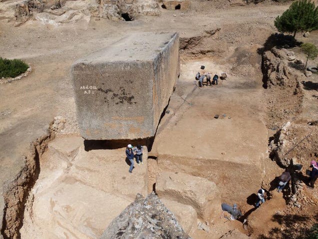
Third Giant Megalith, Weighing 1,650 Tons, Confirmed At Baalbek
By Graham Hancock
30 November 2014
Graham Hancock
I made a research trip to Lebanon in July 2014 and reported here on the recent discovery of a third gigantic megalith in the quarries at Baalbek (in the Beqaa Valley), about a kilometre from the famous Roman temple of Jupiter. Here’s a link to my 11 July report: http://on.fb.me/11EqNqz. Now we have more information from the German Archaeological Institute that has been studying and measuring the newly discovered megalith which is described as 19.60 metres long, 6 metres wide and at least 5.5 metres high. Its weight is estimated at about 1,650 tons which makes it significantly more massive and significantly heavier than the two previously known blocks in situ in the quarry. The German Archaeological Institute's findings are set out on the following pages:
(1) http://bit.ly/1uWvgvs;
Largest ancient stone block discovered in Baalbek Posted by TANNArchaeoHeritage, Archaeology, Breakingnews, Greater Middle East, Lebanon, Near East 5:00 PM
In the summer of 2014 the Oriental Department of the German Archaeological Institute conducted excavations in the stone quarry of Baalbek/Ancient Heliopolis, in Lebanon. There lies the monolith “Hajjar al-Hibla” (Stone of the Pregnant Woman). Similar stone blocks of a 20m-length were used for the podium of the huge Temple of Jupiter in the Roman sanctuary of Baalbek. The largest ancient stone block, found in Baalbek/Lebanon, at an altitude of approximately 1,170 meters [Credit: Deutsches Archäologisches Institut]
The aim of this year’s excavations was to find new data about the mining techniques and the transporting of the megaliths. Archaeologists documented processing traces and investigated the old dumps of the mining activities, in order to locate datable and stratifiable sherds of pottery and small finds. Archaeologists found out that the monolith “Hajjar al-Hibla” was left in the quarry, because the stone quality of a block’s edge proved to be poor and the monolith could easily be damaged during its transport. Below the “Hajjar al-Hibla” and directly beside of it, there is another megalithic stone block, even bigger than the first one: it measures ca. 19,60x6x5,5m. In order to determine the exact height, the trenches should be extended in one of the next archaeological expeditions at the site. The second block weighs 1,650 tons. Archaeologists concluded that the block was meant to be transported without being cut. This means, that it is the biggest known ancient stone block.
Read more at: http://archaeologynewsnetwork.blogspot. ... Hlyj2SsXG9
(2) http://bit.ly/1uRZsIi;
Archaeologists Discover The World's Largest Ancient Stone Block
158,6529
George Dvorsky
Archaeologists Discover The World's Largest Ancient Stone Block
See that absurdly massive stone block? Yeah, that's not the one we're talking about. Look over to the right. German archaeologists working at the Baalbek site in Lebanon have uncovered the largest known ancient block.
The fully exposed block, which dates back to around 27 B.C., is the well known Hajjar al-Hibla. It's located in a stone quarry at Baalbek, site of the ancient Heliopolis in Lebanon. Similar stone blocks measuring up to 20 meters (65 feet) in length and a diameter of 4 x 4 meters (13 x 13 feet) were used for the podium of the massive Temple of Jupiter in the Roman sanctuary of Baalbek.
A few months ago, a team from the German Archaeological Institute conducted excavations at the quarry, and to their amazement they found an ever bigger stone just off to the side and underneath it. It measures 19.6 meters (64 feet) in length, 6 meters (19.6 feet) wide, and is at least 5.5 meters (18 feet) high. Its weight is estimated at a daunting 1,650 tons (that's 3,300,000 pounds, or 1,496,850 kg). Future excavations will confirm its precise dimensions.
The archaeologists concluded that because of the stone's configuration and level of smoothness, the block was meant to be transported without being cut. It's thus the biggest stone block known from antiquity. They're now investigating why the stone was not completed and remained in the quarry — and by what means the Roman builders had to transport it.(3) http://bit.ly/1FGdQLQ;
Biggest Ancient Block of Stone Is Found
IT WEIGHS 1.6K TONS, WAS NEVER MOVED FROM QUARRY
By John Johnson, Newser Staff
Posted Nov 29, 2014 7:32 AM CST
(NEWSER) – Archaeologists studying an ancient quarry that is home to a famously gigantic stone block have now found an even bigger stone block at the site, reports io9. This monster, which dates back to 27 BC, is 64 feet long and 19.6 feet wide. Though it is still mostly buried, researchers estimate that it's 18 feet high and weighs somewhere around 1,650 tons, thus making it the biggest stone block from antiquity, reports the Archaeology News Network. German archaeologists uncovered it in the quarry at Baalbek in what is now Lebanon.
It is next to a fully exposed stone block of similar, but smaller, dimensions, known as Hajjar-al-Hibla, or Stone of the Pregnant Woman. Archaeologists previously determined that Hajjar-al-Hibla was probably left in the quarry because its edges had low-quality stone that might get damaged during transport. Further excavations will try to determine whether the bigger stone block suffered the same fate. It was presumably cut for use in a Roman temple—before ancient builders determined that it wasn't up to snuff. (Click to read about why ancient terracotta warriors looked so realistic.
(4) http://bit.ly/1FFWxso.
The newly discovered block is shown in the first collage of photographs. I am standing on it in the photo at top left and it's front edge is shown in the photo at mid-left. For the record I do NOT agree with the mainstream archaeological view that any of the three megalithic blocks in the quarry, or the enigmatic megalithic foundations of the Temple of the Jupiter, are the work of the Romans. I believe these huge megaliths long predate the construction of the Temple of Jupiter and are likely to be 12,000 or more years old -- contemporaneous with the megalithic site of Gobekli Tepe in Turkey. I suggest we are looking at the handiwork of the survivors of a lost civilisation, that the Romans built their Temple of Jupiter on a pre-existing, 12,000-years-old megalithic foundation, and that they were unaware of the giant hewn megaliths in the ancient quarry as these were covered by sediment in Roman times (as, indeed, the newly discovered block still was until very recently). I set out my reasoning for this point of view in a further report on 14 July and both my 11 July and my 14 July reports are pasted in again below for reference.My report of 11 July 2014. (https://www.facebook.com/Author.GrahamH ... =3&theater)
Baalbek
The first collage of photos is intended to help those who are interested to understand the situation of the main megalithic blocks still in the quarry at Baalbek in Lebanon.
I've stood in on three of the five photos for scale (top left, bottom left and bottom right). These photos feature the so-called "Stone of the Pregnant Woman" which is estimated to weigh a little more than 1,000 tons. Immediately left of it in the photo at bottom left a second huge (mainly buried) megalith has recently been uncovered. I'm standing on top of this recently uncovered megalith in the photo at top left. The photo at left centre shows the front end of this newly uncovered megalith.The photo at top right is of a third megalith in a different part of the quarry that is now used as a rubbish dump (hence the black tyres chucked on top of it). Although this megalith looks smaller than the "Stone of the Pregnant Woman" large parts of it are still buried and calculations suggest it weighs in excess of 1,200 tons.Please note the megaliths featured in this collage are ALL still in the quarry. They are not part of any structure. In my second report (14 July) I focus on the megaliths, some weighing in excess of 800 tons, that were moved a distance of about a mile from the quarry to create a giant platform on top of which the Romans later built a Temple of Jupiter. Mainstream archaeology says all this quarrying and moving of huge megaliths was done by the Romans. Unsurprisingly I believe mainstream archaeology to be wrong! I'll explain further and show photos of the huge blocks on top of which the Temple of Jupiter is built in my next post.My report of 14 July 2014. (https://www.facebook.com/Author.GrahamH ... =3&theater)
Baalbek
See second collage of photos.I'm not persuaded by the archaeological case that the megalithic foundations of the Temple of Jupiter in Baalbek, Lebanon, were the work of the Romans. There's no doubt that the Romans could move very large blocks of stone, and there's no doubt that they were responsible for the classical majesty of the temple itself, but I'm presently working on the assumption that they built it on top of a megalithic platform that had already been in place for thousands of years. The western side of that original (and I believe remotely ancient) megalithic platform is shown in the collage of photographs with this post. On top of six megaliths, in the range of 400 tons each, are prominently positioned three gigantic megaliths weighing approximately 800 tons each. I am aware that megaliths even larger than this (e.g. the so-called Thunder Stone of St Petersburg) have been moved and positioned on flat ground in historical times) but the moving and positioning of three 800 ton megaliths to a height of 18 or 20 feet above the ground as is the case at Baalbek is a problem of a completely different order. I suggest this requires careful consideration rather than simply saying "the Romans did it" as archaeology is at present inclined to do.I have many reasons for this view, to do with the possibility of a lost civilisation that I will be exploring in depth in "Magicians of the Gods", the sequel to "Fingerprints of the Gods" (to be published October 2015). However to consider just a single point here we need only turn to the quarry at Baalbek where a number of even larger megaliths (but clearly of the same type as the 800-ton blocks under the Temple of Jupiter), were left in situ by whoever conceived it possible to build with megaliths on this scale. If it was the Romans who quarried and moved everything than we have to ask ourselves why three huge blocks in the range of 1,000 to 1,650 tons were left in the quarry at all.
The conventional answer is that the Romans, having quarried these exceptionally large blocks, found that they could not move them and simply abandoned them. But that explanation makes very little sense. If the argument that the Romans were responsible for the megalithic platform is correct then we know that they went on to build an extensive temple complex dedicated to Jupiter using smaller blocks of stone. Surely their first source for the multiple smaller blocks they needed would have been the huge megaliths that, according to the argument of mainstream archaeology, they had discovered they could not move from the quarry? The Romans were practical people who would not allow work that they had already so painstakingly done to go to waste. Rather than opening up fresh quarry faces, wouldn't they have used those massive, already almost completely quarried 1,000-ton-plus blocks and simply sliced them up into smaller more moveable megaliths for the construction of the rest of the temple?
It's really puzzling that they didn't do so and therefore the fact that these gigantic, almost finished blocks remain in the quarry and were never sliced up into smaller blocks and used in the general construction of the Temple of Jupiter, suggests to me very strongly that the Romans did not even know they were there. Most probably they had been buried under many metres of sediment for many thousands of years when the Romans appeared on the scene. They made use of the megaliths that were already in place on the already remotely ancient sacred site that would become the Temple of Jupiter -- a handy, massive and convenient platform upon which they could build their temple -- but they knew nothing of the fully cut and shaped but unused megaliths lying deeply buried in the quarry. This is a working hypothesis at the moment, nothing more, but I will explore its implications fully in “Magicians of the Gods”.
![]() by Searcher08 » Wed Dec 03, 2014 4:07 pm
by Searcher08 » Wed Dec 03, 2014 4:07 pm


Users browsing this forum: No registered users and 8 guests